
Wintego Rapids (Rapid 3)
Away today at our usual time, on another beautiful calm morning with no wind. We paddled south around the island, (it was an interesting question as to which was actually shorter, north or south). We could see that the “antenna” was really just a big tree (and from this angle it didn’t look so tall). The building had no sign of life around it at all.
We paddled to the top of Wintego rapids (13 U 636760 6160978). We stopped at a rock point about a hundred metres short of the rapids, not certain what we would find around the corner, and got out to look. We could easily see where the portage started around this point, and in a bay. There was only a small amount of current to round this point. At the portage site there were a few old sticks, but not much other sign that it is used often. Had we had another canoe with us for safety we would probably have run the rapids, as they were not too difficult. It looks as if you could run them down the right side out into the edge of the chute (however we didn’t look at them very carefully). There is the Wintego water survey station on this portage trail, which has a solar panel and antenna.
There was a bit of current and eddy after the portage, but nothing too major. We paddled on to the next rapids, the first of the three large rapids (13 U 637950 6161738) at the end of the channel, (what I would call the major part of Wintego). At this first rapids the river swings hard to the right, and you really can’t see the top of the rapids at all until you round the bend. We paddled out to where I thought we could see what was coming. I realized that we wanted to go close to the river right shore around the point, then pull in to a long rock ledge that sticks out about 100 m past the first point. This ledge had almost no water flowing over it, so it would be easy to portage on the rocks.
We turned the canoe to paddle back to make our way to the right shore, and down around the bend. However, the current was stronger than I thought, and we were not making very good progress upstream. We were probably about 20 m from shore, but I didn’t think we were going to make it far enough upstream to line up correctly, so told Graeme to swing around and go down the river. As we turned in the current, we were swung over hard and tipped badly, and had both of us not braced hard would probably have flipped. We did make it around the turn fine, pulled into the eddy properly behind the point and made our way to the rock point ledge. Here we portaged over about 40 or 50 m on the rocks, then paddled down to the second rapids (13 U 638250 6161822).

Portaging Wintego Rapids (Rapid 3)
At this water level it would be very hard to shoot this part on the right, as it is too steep and shallow of a ledge. There looks like an easy run down river left, but that would be very dangerous as you would have only about 100 m to cross back over the entire river to get to the right hand side for the portage of the third and major rapids. From this second portage we made on the right it is 200 m of easy relatively quiet water across to the rocky point that makes up the portage for the third rapids.
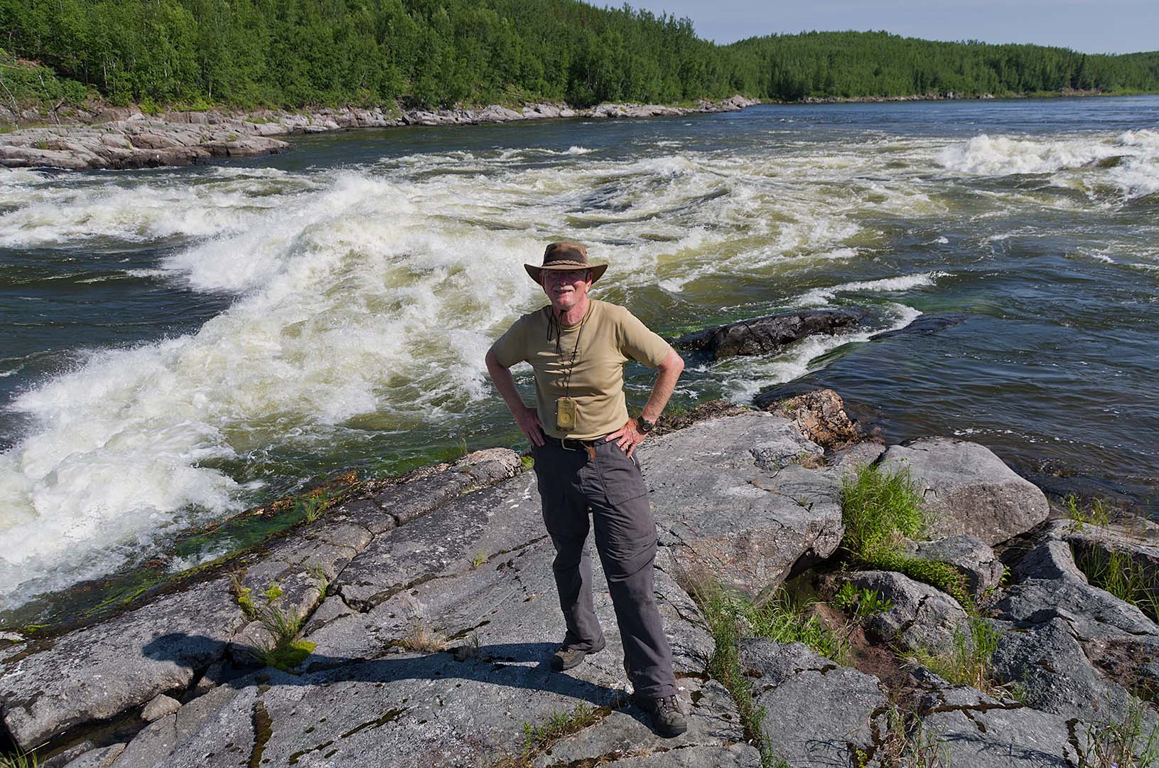
David at Wintego Rapids (Rapid 4)
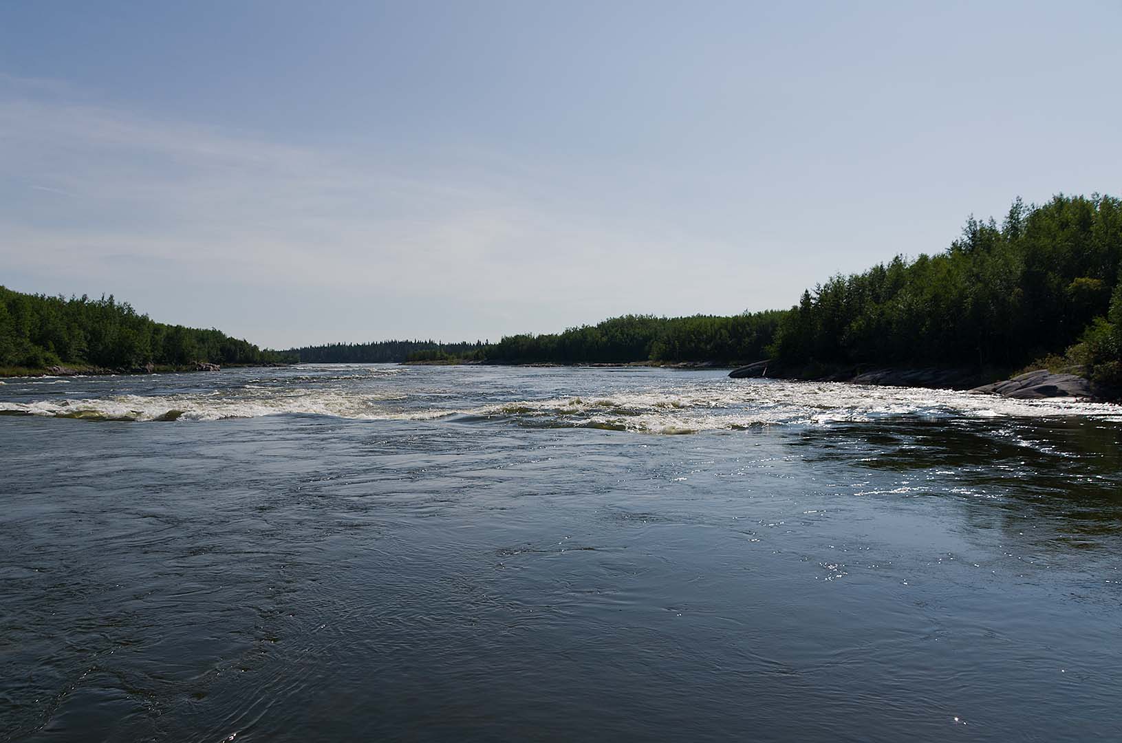
The third rapids (13 U 638490 6161910) in this set (Wintego Rapid 4) is the most spectacular. It is very narrow, maybe 30 or 40 m wide, and there is a large ledge over which the water boils, then hits a second ledge and forms a huge curling hole and haystack wave. We stayed here for quite a while to take photographs. It is the bookend with Kettle Falls around Wapumon Gorge, the three most spectacular rapids and falls on the Churchill River in Saskatchewan.
Below the third rapids is more fast water, and in about a kilometre a large river wide ledge (13 U 639606 6161432) rapids that has an island in the middle (Enid and I camped on this island in 1977). We went down the right hand channel, quite close to river left shore. There is a break in the ledge here not far out from the left hand shore.
We took the south route around Duncan Island (the north route has one larger rapid). We came to the first southeren rapids (13 U 639802 6159442) that we started to shoot on the left. We soon felt that there was probably a ledge there (there was a large flat rock) so we crossed a long ways over to the right to hit the main channel. This was fine, except that at the bottom was a strong eddy line. We stayed to the right to avoid the eddy line, and got into a bit of choppy water.
We stopped to eat lunch on a nice island (13 U 640149 6158033) at the end of Duncan Island. Although it’s been burned over, the burn is a long time ago and so most of the area is recovering. The last rapids of the day (13 U 641422 6158538) was after lunch. It is an easy run, but quite long. The waves were interesting, as they formed criss-crossing standing waves (not breaking) making a unique pattern on the water.
By noon it was starting to become quite windy, but since it was mostly from the east southeast it pushed us along as much as anything . My left hand is very sore, as I must have tendonitis. Graeme has some in his left elbow, so we were both glad we didn’t have to fight the wind.
After rounding the point at the end of Pita Lake we crossed over the lake to the east shore to escape the worst of the wind, but also because there is supposed to be a campsite there. We didn’t see anything much as it looked too high, so continued on to this one. It is big enough for a couple of tents. The only problem is that there is a lot of decaying organic matter in the line of grasses and willows that are just to the east. The water level has dropped, and the vegetation is starting to rot, and it smells.
After setting up camp, sawing and splitting wood, and swimming, we took the canoe out fishing. We caught quite a few small jacks, and threw them away until I finally caught a decent sized one (big enough to eat anyway). We both had bites, or hooked fish which also got off. The next one I caught dove into the weeds. At first I had been able to reel it in, but then it got so tangled in the weeds that I couldn’t bring it in. Finally I grabbed the line and pulled it free. There were more weeds than fish. Graeme finally caught one that was big enough to eat as well, so we took in three fish. We had a lot of fish for supper, in fact more than we could eat.
When we went fishing it seemed very much like it would rain. All day a band of clouds kept increasing in the western sky until by mid-afternoon it was overhead. However, it hasn’t rained, and it appears as if this cloud may be moving off, though there are also some storm cells to the north. There were a lot of deer flies out earlier when it was so very hot this afternoon, but they seem to be gone now.
Graeme is suffering from the sun. Despite heavy application of sunscreen his upper arms are getting very pink. I’m not doing too badly, but it certainly has been warm the past few days.
Paddled 18.93 km
Camped 13 U 0644389 6161175 (NAD83)