Alexander Mackenzie's Journal
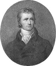 Alexander Mackenzie's journal of his travels through
(current) northern Canada was published in England in 1801 as Voyages from Montreal on
the River St. Laurence Through the Continent of North America to the Frozen and Pacific
Oceans In the Years 1789 and 1793. The travelogue begins with "A General History
of the Fur Trade", which describes the water route from Montreal to Lake Athabasca.
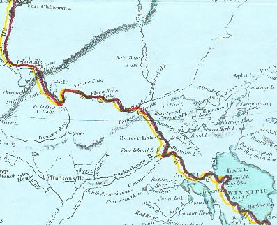
The following contains the portion of Mackenzie's journal describing the fur trade route
within the current boundaries of the Province of Saskatchewan. Alexander Mackenzie's journal of his travels through
(current) northern Canada was published in England in 1801 as Voyages from Montreal on
the River St. Laurence Through the Continent of North America to the Frozen and Pacific
Oceans In the Years 1789 and 1793. The travelogue begins with "A General History
of the Fur Trade", which describes the water route from Montreal to Lake Athabasca.
The following contains the portion of Mackenzie's journal describing the fur trade route
within the current boundaries of the Province of Saskatchewan.
Mackenzie's original spelling and punctuation has been retained, except that the script
 has been replaced by the modern s to make the text easier to read.
Modern place names that correspond to Mackenzie's, and comments about his text are noted
parenthetically in a green font. has been replaced by the modern s to make the text easier to read.
Modern place names that correspond to Mackenzie's, and comments about his text are noted
parenthetically in a green font. |
On entering the Saskatchiwine [Saskatchewan River], in the
course of a few miles, the great rapid [Grand Rapids]
interrupts the passage. It is about three miles long. Through the greatest part of it the
canoe is towed, half or full laden, according to the state of the waters: the canoe and
its contents are then carried one thousand one hundred paces. The channel here is near a
mile wide, the waters tumbling over ridges of rocks that traverse the river. The south
bank is very high, rising upwards of fifty feet, of the same rock as seen on the South
side of the Lake Winipic, [Lake Winnipeg] and the North is
not more than a third of that height. There is an excellent sturgeon fishery at the foot
of this cascade, and vast numbers of pelicans, cormorants, &c. frequent it, where they
watch to seize the fish that may be killed or disabled by the force of the waters.
[The entire area described in the next three paragraphs is
flooded by the Grand Rapids Dam at the mouth of the Saskatchewan River, where it empties
into Lake Winnipeg.]
About two miles from this Portage the navigation is again interrupted by the Portage of
the Roché Rouge, which is an hundred yards long; and a mile and an half from thence the
river is barred by a range of islands, forming rapids between them; and through there it
is the same distance to the rapid of Lake Travers, which is four miles right across, and
eight miles in length. Then succeeds the Grande Décharge, and several rapids, for four
miles to the Cedar Lake, which is entered through a small channel on the left, formed by
an island, as going round it would occasion loss of time. In this distance banks of rocks
(such as have already been described), appear at intervals on either side; the rest of the
country is low. This is the case along the South bank of the lake and the islands, while
the North side, which is very uncommon, is level throughout. This lake runs first West
four miles, then as much more West-South-West, across a deep bay on the right, then six
miles to the Point de Lievre, and across another bay again on the right; then North-West
eight miles, across a still deeper bay on the right; and seven miles parallel with the
North coast, North-North-West through islands, five more miles to Fort Bourbon*,
| *This was also a principal post of the French, who gave it
its name. |
situated on a small island dividing this from Mud-Lake.
The Cedar Lake is from four to twelve miles wide, exclusive of the bays. Its banks are
covered with wood, and abound in game, and its waters produce plenty of fish, particularly
the sturgeon. The Mud-Lake, and the neighbourhood of the Fort Bourbon, abound with geese,
ducks, swans, &c. and was formerly remarkable for a vast number of martens, of which
it cannot now boast but a very small proportion.
The Mud-Lake [Saskatchewan River Delta] must have formerly
been a part of the Cedar Lake, but the immense quantity of earth and sand, brought down by
the Saskatchiwine, has filled up this part of it for a circumference whose diameter is at
least fifteen or twenty miles: part of which space is still covered with a few feet of
water, but the greatest proportion is shaded with large trees, such as the liard, the
swamp-ash, and the willow. This land consists of many islands, which consequently form
various channels, several of which are occasionally dry, and bearing young wood. It is,
indeed, more than probable that this river will, in the course of time, convert the whole
of the Cedar Lake, into a forest. To the North-West the cedar is not to be found.
[This is the approximate boundary of the present province of
Saskatchewan.]
From this lake the Saskatchiwine may be considered as navigable to near its sources in
the rocky mountains, for canoes, and without a carrying-place, making a great bend to
Cumberland House, on Sturgeon Lake. From the confluence of its North and South branches [The Forks, near Prince Albert] its course is Westerly; spreading,
itself, it receives several tributary streams, and encompasses a large track of country,
which is level, particularly along the South branch, but is little known. Beaver, and
other animals, whore furs are valuable, are amongst the inhabitants of the North-West
branch, and the plains are covered with buffalos, wolves, and small foxes; particularly
about the South branch, which, however, has of late claimed some attention, as it is now
understood, that where the plains terminate towards the rocky mountain, there is a space
of hilly country clothed with wood, and inhabited also by animals of the fur kind. This
has been actually determined to be the case towards the head of the North branch, where
the trade has been carried to about the latitude 54 North, and longitude 114 1/2. West.
The bed and banks of the latter, in some few places, discover a stratum of free-stone;
but, in general, they are composed of earth and sand. The plains are sand and gravel,
covered with fine grass, and mixed with a small quantity of vegetable earth. This is
particularly observable along the North branch, the West side of which is covered with
wood.
There are on this river five principal factories for the convenience of trade with the
natives. Nepawi House, South-branch House, Fort George House, Fort-Augustus House, and
Upper Establishment. There have been many others, which, from various causes, have been
changed for there, while there are occasionally others depending on each of them.
The inhabitants, from the information I could obtain, are as follow :
At Nepawi, and South-Branch House, about thirty tents of Knisteneaux, or ninety
warriors; and fifty tents of Stone-Indians, or Assiniboins, who are their neighbours, and
are equal to two hundred men: their hunting ground extends upwards to about the Eagle
Hills. Next to them are those who trade at Forts George and Augustus, and are about eighty
tents or upwards of Knisteneaux: on either side of the river, their number may be two
hundred. In the same country are one hundred and forty tents of Stone-Indians; not quite
half of them inhabit the West woody country; the others never leave the plains, and their
numbers cannot be less than four hundred and fifty men. At the Southern Headwaters of the
North branch dwells a tribe called Sarsees, consisting of about thirty-five tents, or one
hundred and twenty men. Opposite to those Eastward, on the headwaters of the South Branch,
are the Picaneaux, to the number of from twelve to fifteen hundred men. Next to them, on
the same water, are the Blood-Indians, of the same nation as the last to the number of
about fifty tents, or two hundred and fifty men. From them downwards extend the Black-Feet
Indians, of the same nation as the two last tribes: their number may be eight hundred men.
Next to them, and who extend to the confluence of the South and North branch, are the
Fall, or Big-bellied Indians, who may amount to about six hundred warriors.
Of all there different tribes, those who inhabit the broken country on the North-West
side, and the source of the North branch, are beaverhunters; the others deal in
provisions, wolf, buffalo, and fox skins; and many people on the South branch do not
trouble themselves to come near the trading establishments. Those who do, choose such
establishments as are next to their country. The Stone-Indians here, are the same people
as the Stone-Indians, or Assiniboins, who inhabit the river of that name already described
and both are detached tribes from the Nadawasis, who inhabit the Western side of the
Mississippi, and lower part of the Missisoury. The Fall, or Big-bellied Indians, are from
the South-Eastward also, and of a people who inhabit the plains from the North bend of the
last mentioned river, latitude 47.32. North, longitude 101. 25. West, to the South bend of
the Assiniboin River, to the number of seven hundred men. Some of them occasionally come
to the latter river to exchange dressed buffalo robes, and bad wolf-skins for articles of
no great value.
The Picaneaux, Black-Feet, and Blood-Indians, are a distinct people, speak a language
of their own, and, I have reason to think, are travelling North-Westward, as well as the
others just mentioned: nor have I heard of any Indians with whose language, that which
they speak has any affinity. They are the people who deal in horses and take them upon the
war-parties towards Mexico; from which, it is evident, that the country to the South-East
of them, consists of plains, as those animals could not well be conducted through an hilly
and woody country, intersected by waters.
The Sarsees, who are but few in number, appear from their language, to come on the
contrary from the North-Westward, and are of the same people as the Rocky-Mountain Indians
described in my second journal, who are a tribe of the Chepewyans; and, as for the
Knisteneaux, there is no question of their having been, and continuing to be, invaders of
this country, from the Eastward. Formerly, they struck terror into all the other tribes
whom they met; but now they have loft the respect that was paid them; as those whom they
formerly considered as barbarians, are now their allies, and consequently become better
acquainted with them, and have acquired the use of fire-arms. The former are still proud
without power, and affect to consider the others as their inferiors: those consequently
are extremely jealous of them, and, depending upon their own superiority in numbers, will
not submit tamely to their insults; so that the consequences often prove fatal and the
Knisteneaux are thereby decreasing both in power and number: Spirituous liquors also tend
to their diminution, as they are instigated thereby to engage in quarrels which frequently
have the most disastrous termination among themselves.
The Stone-Indians must not be considered in the same point of view respecting the
Knisteneaux, for they have been generally obliged, from various causes, to court their
alliance. They, however, are not without. their disagreements, and it is sometimes very
difficult to compote their differences. These quarrels occasionally take place with the
traders, and sometimes have a tragical conclusion. They generally originate in consequence
of stealing women and horses: they have great numbers of the latter throughout their
plains, which are brought, as has been observed, from the Spanish Settlements in Mexico;
and many of them have been seen even in the back parts of this country, branded with the
initials of their original owners names.
Those horses are distinctly employed as beasts of burden, and to chase the buffalo. The
former are not considered as being of much value, as they may be purchased for a gun,
which costs no more than twenty-one pounds in Great-Britain. Many of the hunters cannot be
purchased with ten, the comparative value, which exceeds the property of any native.
Of there useful animals no care whatever is taken, as when they are no longer employed,
they are turned loose winter and summer to provide for themselves. Here, it is to be
observed ' that the country, in general, on the West and North side of this great river,
is broken by the lakes and rivers with small intervening plains, where the foil is good,
and the grass grows to some length. To there the male buffalos resort for the winter, and
if it be very severe, the females also are obliged to leave the plains.
But to return to the route by which the progress West and North is made through this
continent.
[Changes to the course of the Saskatchewan River have caused
significant changes to the topography of the area around Cumberland House. I have
indicated what I believe to be the current lakes closest to the areas Mackenzie describes.]
We leave the Saskatchiwine* by entering the river which forms the discharge of the
| * It may be proper to observe, that the France had two
settlements upon the Saskatchiwine, long before, and at the conquest of Canada; the first
at the Pasquia, near Carrot River, and the other at Nipawi, [Nipawin] where they had agricultural instruments and
wheel carriages, marks of both being found at those establishments, where the soil is
excellent |
Sturgeon Lake [Namew Lake], on whose East bank is situated
Cumberland house, in latitude 53.56. North, longitude 102.15. The distance between the
entrance of the lake and Cumberland house is estimated at twenty miles. It is very evident
that the mud which is carried down by the Saskatchiwine River, has formed the land that
lies between it and the lake, for the distance of upwards of twenty miles in the line of
the river, which is inundated during one half of the summer, though covered with wood.
This lake forms an irregular horse-shoe, one side of which runs to the North-West, and
bears the name of Pine-Island Lake [Cumberland Lake], and the
other known by the name already mentioned, runs to the East of North, and is the largest:
its length is about twenty-seven miles, and its greatest breadth about six miles. The
North side of the latter is the same kind of rock [limestone]
as that described in Lake Winipic [Lake Winnipeg], on the
West shore. In latitude 54.16. North, the Sturgeon-Weir River discharges itself into this
lake [Namew Lake], and its bed appears to be of the same kind
of rock, and is almost a continual rapid. [The Sturgeon-Weir
river was called the Maligne by the voyageurs, because of its steep gradient and frequent
shallow stony rapids.] Its direct course is about West by North, and
with its windings, is about thirty miles. It takes its waters into the Beaver Lake [Amisk Lake], the South-West side of which consists of the same rock
lying in thin stratas: the route then proceeds from island to island for about twelve
miles, and along the North shore, for four miles more, the whole being a North-West course
to the entrance of a river, in latitude 54.32. North. The lake, for this distance, is
about four or five miles wide, and abounds with fish common to the country. The part of it
upon the right of that which has been described, appears more considerable. The islands
are rocky, and the lake itself surrounded by rocks. The communication from hence to the
Bouleau Lake, [Birch Portage] alternately narrows into rivers
and spreads into small lakes. The interruptions are, the Pente, [Spruce
Rapids?] which is succeeded by the Grand Rapid, [Scoop
Rapids?] where there is a Décharge, the Carp Portage, [Leaf
Rapids? – other sources refer to Scoop Rapids as Carp
Portage] the Bouleau Portage [Birch Portage] in
latitude 54.50. North, including a distance, together with the windings, of thirty-four
miles, in a Westerly direction. The Lake de Bouleau then follows. This lake might with
greater propriety, be denominated a canal, as it is not more than a mile in breadth. Its
course is rather to the East of North for twelve miles to Portage de L'Isle [Dog Portage]. From thence there is still water to Portage
d'Epinettes, [Corneille Rapids] except an adjoining rapid.
The distance is not more than four miles Westerly. After crossing this Portage, it is not
more than two miles to Lake Miron, [Mirond Lake] which is in
latitude 55.7. North. Its length is about twelve miles, and its breadth irregular, from
two to ten miles. It is only separated from Lake du Chitique, or Pelican Lake, by a short,
narrow, and small strait. That lake is not more than seven miles long, and its course
about North-West. The Lake des Bois then succeeds, the passage to which is through small
lakes, separated by falls and rapids. The first is a Décharge: [Medicine
Rapids] then follow the three galets [small falls], in
immediate succession. From hence Lake des Bois [Wood Lake]
runs about twenty-one miles. Its course is South-South-East, and North-North-West, and is
full of islands. The passage continues through an intricate, narrow, winding, and shallow
channel for eight miles. The interruptions in this distance are frequent, but depend much
on the state of the waters. Having passed them, it is necessary to cross the Portage de
Traite, [Frog Portage] or, as it is called by the Indians,
Athiquisipichigan Ouinigam, or the Portage of the Stretched Frog-Skin, to the Missinipi.
The waters already described discharge themselves into Lake Winipic, and augment those of
the river Nelson. These which we are now entering are called the Missinipi, or great
Churchill River.
All the country to the South and East of this, within the line of the progress that has
been described, is interspersed by lakes, hills, and rivers, and is full of animals, of
the fur-kind, as well as the moose-deer. Its inhabitants are the Knisteneaux Indians, who
are called by the servants of the Hudson’s-Bay Company, at York, their home-guards.
The traders from Canada succeeded for several years in getting the largest proportion
of their furs, till the year 1793, when the servants of that company thought proper to
fend people amongst them, (and why they did not do it before is best known to themselves),
for the purpose of trade, and securing their credits' which the Indians were apt to
forget. From the short distance they had to come, and the quantity of goods they supplied,
the trade has, in a great measure, reverted to them, as the merchants from Canada could
not meet them upon equal terms. What added to the loss of the latter, was the murder of
one of their traders, by the Indians, about this period. Of there people not above eighty
men have been known to the traders from Canada, but they consist of a much greater number.
The Portage de Traite, as has been already hinted, received its name from Mr. Joseph
Frobisher, who penetrated into this part of the country from Canada, as early as the years
1774 and 1775, where he met with the Indians in the spring, on their way to Churchill,
according to annual custom, with their canoes full of valuable furs. They traded with him
for as many of them as his canoes could carry, and in consequence of this transaction, the
Portage received and has since retained its present appellation. He also denominated these
waters the English River. The Missinipi, is the name which it received from the
Knisteneaux when they first came to this country, and either destroyed or drove back the
natives, whom they held in great contempt, on man accounts, but particularly for their
ignorance in hunting the beaver, as well as in preparing, stretching, and drying, the
skins of those animals. And as a sign of their derision, they stretched the skin of a
frog, and hung it up at the Portage. This was, at that time, the utmost extent of their
conquest or warfaring-progress West, and is in latitude 55.25. North, and longitude 103
3/4. West. The river here, [Trade Lake] which bears the
appearance of a lake, takes its name from the Portage, and is full of islands. It runs
from East to West about fifteen miles, and is from four to five miles broad. Then succeed
falls and cascades which form what is called the grand rapid. [Grand
Rapids] From thence there is a succession of small lakes and rivers, interrupted by
rapids and falls, viz. the Portage de Bareel, [Keg Falls] the
Portage de L’Isle, [Island Portage] and that of the
Rapid River. [Potter Rapids] The course is twenty miles from
East-South-East to North-North-West. The Rapid-River Lake [Nistowiak
Lake] then runs West five miles, and is of an oval form. The rapid river is the
discharge of Lake la Ronge, where there has been an establishment for trade from the year
1782. Since the small pox ravaged there parts, there have been but few inhabitants; there
are of the Knisteneaux tribe, and do not exceed thirty men. The direct navigation
continues to be through rivers and canals, interrupted by rapids; and the distance to the
first Décharge is four miles, [Stanley Rapids] in a Westerly
direction. Then follows Lake de la Montagne, [Mountain Lake]
which runs South-South-West three miles and an half, then North six miles, through narrow
channels, formed by islands, and continues North-North-West five miles, to the portage of
the same name, [Mountain Portage - Twin Falls] which is no
sooner crossed, than another appears in right, [Stony Mountain
Portage] leading to the Otter Lake, from whence it is nine miles Westerly to the
Otter Portage, [Otter Rapids] in latitude 55.39.
Between this and the Portage du Diable, [Great Devil Rapids.
There are significant differences between Mackenzie's names and the modern names of the
lakes in the area upstream of Otter Rapids to Black Bear Island Lake. It appears
that Mackenzie is describing the route through the current Great and Little Devil Rapids.
On modern maps Devil Lake is the lake before Devil Rapids, not following it as
Mackenzie describes.] are several rapids, and the distance three miles and an half.
Then succeeds the lake of the same name, [On modern maps these lakes
are Hayman Lake and Nipew (Dead) Lake.] running from South-East to North-West, five
miles, and West four miles and an half. There is then a succession of small lakes,
rapids, and falls, producing the Portage des Ecors, [Rock Trout
Portage] Portage du Galet, [Stack Lake Rapids] and
Portage des Morts, [Trout Rapids] the whole comprehending a
distance of six miles, to the lake of the latter name [Trout Lake.
On older maps, Nipew Lake is named Dead Lake. From Mackenzie's description it would appear
that he is referring to Trout Lake as Dead Lake]. On the left side is a point
covered with human bones, the relics of the small pox; which circumstance gave the Portage
and the lake this melancholy denomination. Its course is South-West fifteen miles, while
its breadth does not exceed three miles. From thence a rapid river leads to Portage de
Hallier, [Birch Rapids] which is followed by Lake de
L’Isle d'Ours: [Black Bear Island Lake] it is, however,
improperly called a lake, as it contains frequent impediments amongst its islands, from
rapids. There is a very dangerous one about the centre of it, which is named the Rapid qui
ne parle point, [Silent Rapids] or that never speaks, from
its silent whirlpool-motion. In some of the whirlpools the suction is so powerful, that
they are carefully avoided. [It is hard to understand how this rapid
could have been considered so dangerous. Perhaps it was the voyageur's misunderstanding of
what whirlpools were – perhaps a belief that they would suck one into the underworld.
Or prehaps it was a voyageur's joke, for the rapid itself is really little more than fast
water and large eddies.] At some distance from the silent rapid, is a narrow
strait, where the Indians have painted
red figures on the face of a rock, and where it was their custom formerly to make an
offering of some of the articles which they bad with them, in their way to and from
Churchill. The course in this lake, which is very meandering, may be estimated at
thirty-eight miles, and is terminated by the Portage du Canot Tourner, [Needle Falls] from the danger to which those are subjected who
venture to run this rapid. From thence a river of one mile and an half North-West course
leads to the Portage de Bouleau, [Needle Rapids (Part II)]
and in about half a mile to Portage des Epingles, [Needle Rapids
Part I – the rapids at the outlet of Sandfly Lake)] so called from the
sharpness of its stones. Then follows the Lake des Souris, [Sandfly
Lake] the direction across which is amongst islands, North-West by West six miles.
In this traverse is an island, which is remarkable for a very large stone, in the form of
a bear, on which the natives have painted the head and snout of that animal; and here they
also were formerly accustomed to offer sacrifices. This lake is separated only by a narrow
strait from the Lake du Serpent, [Pinehouse (Snake) Lake]
which runs North-North-West seven miles, to a narrow channel, that connects it with
another lake, bearing the same name, and running the same course for eleven miles, when
the rapid [Snake Rapids] of the same denomination is entered
on the West side of the lake. It is to be remarked here, that for about three or four
miles on the North-West side of this lake, there is an high bank of clay and sand, clothed
with cypress trees, a circumstance which is not observable on any lakes hitherto
mentioned, as they are bounded, particularly on the North, by black and grey rocks. It may
also be considered as a most extraordinary circumstance, that the Chepewyans, go
North-West from hence to the barren grounds, which are their own country, without the
assistance of canoes; as it is well known that in every other part which has been
described, from Cumberland House, the country is broken on either ride of the direction to
a great extent: so that a traveller could not go at right angles with any of the
water. The last mentioned rapid [Snake Rapids] is
upwards of three miles long, North-West by West; there is, however, no carrying, as the
line and poles are sufficient to drag and set the canoe against the current. Lake Croche [Sandy, and Dreger Lakes] is then crossed in a Westerly direction of
six miles, though its whole length may be twice that distance; after which it contracts to
a river that runs Westerly for ten miles, when it forms a bend, which is left to the
South, and entering a portion of its waters called the Grass River, [Haultain
River] whose meandering course is about six miles, but in a direct line not more
than half that length, where it receives its waters from the great river, which then runs
Westerly eleven miles before it forms the Knee Lake, [Knee Lake]
whose direction is to the North of West. It is full of islands for eighteen miles, and its
greatest apparent breadth is not more than five miles. The portage [Knee
Rapids] of the same name is several hundred yards long, and over large stones. Its
latitude is 55.50. and longitude 106.30. [The actual longitude of
this rapid is about 107.5. This is one of the largest errors in longitude in Mackenzie's
description. Throughout most of his journal he is amazingly accurate, rarely more
than a few seconds off.] Two miles further North is the commencement of the Croche
Rapid, [Crooked Rapids] which is a succession of cascades for
about three miles, making a bend due South to the Lake du Primeau, [Primeau
Lake] whose course is various, and through islands, to the distance of about
fifteen miles. The banks of this lake are low, stony, and marshy, whose grass and rushes,
afford shelter and food to great numbers of wild fowl. At its Western extremity is Portage
la Puife, [Dreger Rapids. These are very small rapids,
virtually no more than a fast current in the water, though doubtless one could not have
run them in a loaded birchbark canoe.] from whence the river takes a meandering
course, widening and contracting, at intervals, and is much interrupted by rapids [The Haultain area has some sections of strong current, and perhaps a few
shallow stones, and does take a very winding course, but there are no true rapids in this
stretch of the river.]. After a Westerly course of twenty miles, it reaches Portage
Pellet. [Dipper Rapids] From hence, in the course of seven
miles, are three rapids, [Deer, Leaf, and Drum Rapids] to
which succeeds the Shagoina Lake, [Shagwenaw Lake] which may
be eighteen miles in circumference. Then Shagoina Lake and rapid [Shagwenaw
Rapids] lead into the Lake of Isle a la Croisé, [Lac Ile a
la Crosse] in which the course is South twenty miles, and South-South-West fourteen
miles, to the Point au Sable; opposite to which is the discharge of the Beaver-River,
bearing South six miles: the lake in the distance run, does not exceed twelve miles in its
greatest breadth. It now turns West-South-West, the isle a la Croisé being on the South,
and the main land on the North; and it clears the one and the other in the distance of
three miles, the water presenting an open horizon to right and left: that on the left
formed by a deep narrow bay, about ten leagues in depth; and that to the right by what is
called la Riviere Creufe, [Aubichon Arm] or Deep River, being
a canal of still water, which is here four miles wide. On following the last course, Isle
a la Crosse Fort appears on a low isthmus, at the distance of five miles, and is in
latitude 55.25. North, and longitude 107.48. West.s already mentioned, without meeting
with others in every eight or ten miles. This will also be found to be very much the case
in proceeding to Portage la Loche.
This lake and fort take their names from the island just mentioned, which, as has been
already observed, received it denomination from the game of the cross, which forms a
principal amusement among the natives.
The situation of this lake, the abundance of the finest fish in the world to be found
in its waters, the richness of its surrounding banks and forests, in moose and fallow
deer, with the vast numbers of the smaller tribes of animals, whose skins are precious,
and the numerous flocks of wild fowl that frequent it in the spring and fall, make it a
most desirable spot for the constant residence of some, and the occasional rendezvous of
others of the inhabitants of the country, particularly of the Knisteneaux.
Who the original people were that were driven from it, when conquered by the
Knisteneaux is not now known, as not a single vestige remains of them. The latter, and the
Chepewyans, are the only people that have been known here; and it is evident that the
last-mentioned consider themselves as strangers, and seldom remain longer than three or
four years, without visiting their relations and friends in the barren grounds, which they
term their native country. They were for sometime treated by the Knisteneaux as enemies;
who now allow them to hunt to the North of the track which has been described, from Fort
du Trait upwards, but when they occasionally meet them, they insist on contributions, and
frequently punish resistance with their arms. This is sometimes done at the forts, or
places of trade, but then it appears to be a voluntary gift. A treat of rum is expected on
the occasion, which the Chepewyans on no other account ever purchased; and those only who
have had frequent intercourse with the Knisteneaux have any inclination to drink it.
When the Europeans first penetrated into this country, in 1777, the people of both
tribes were numerous, but the small pox was fatal to them all, so that there does not
exist of the one, at present, more than forty resident families; and the other has been
from about thirty to two hundred families. These numbers are applicable to the constant
and less ambitious inhabitants, who are satisfied with the quiet possession of a country
affording, without risk or much trouble, every thing necessary to their comfort; for since
traders have spread themselves over it, it is no more the rendezvous of the errant
Knisteneaux, part of whom used annually to return thither from the country of the Beaver
River, which they had explored to its source in their war and hunting excursions and as
far as the Saskatchiwine, where they sometimes met people of their own nation, who had
prosecuted similar conquests up that river. In that country they found abundance of fish
and animals, such as have been already described, with the addition of the buffalos, who
range in the partial patches of meadow scattered along the rivers and lakes. From thence
they returned in the spring, to the friends whom they had left; and, at the same time met
with others who bad penetrated, with the same designs, into the Athabasca country, which
will be described hereafter.
The spring was the period of this joyful meeting, when their time was occupied in
feasting, dancing, and other pastimes, which were occasionally suspended for sacrifice,
and religious solemnity: while the narratives of their travels, and the history of their
wars amused and animated the festival. The time of rejoicing was but short, and was soon
interrupted by the necessary preparations for their annual journey to Churchill, to
exchange their furs for such European articles as were now become necessary to them. The
shortness of the seasons, and the great length of their way requiring the utmost dispatch,
the most active men of the tribe, with their youngest women, and a few of their children
undertook the voyage, under the direction of some of their chiefs, following the waters
already described, to their discharge at Churchill Factory, which are called, as has
already been observed, the Missinipi, or Great Waters. There they remained no longer than
was sufficient to barter their commodities, with a supernumerary, and a day or two to
gratify themselves with the indulgence of spirituous liquors. At the same time the
inconsiderable quantity they could purchase to carry away with them, for a regale with
their friends, was held sacred, and reserved to heighten the enjoyment of their return
home, when the amusements, festivity, and religious solemnities of the spring were
repeated. The usual time appropriated to there convivialities being completed, they
separated, to pursue their different objects; and if they were determined to go to war,
they made the necessary arrangements for their future operations.
But we must now renew the progress of the route. It is not more than two miles from
Isle a la Crosse Fort, to a point of land which forms a cheek of that part of the take
called the Riviere Creufe, which preserves the breadth already mentioned for upwards of
twenty miles; then contracts to about two, for the distance of ten miles more, when it
opens to Lake Clear, [Churchill Lake] which is very wide, and
commands an open horizon, keeping the West shore for six miles. The whole of the distance
mentioned is about North-West, when, by a narrow, crooked channel, turning to the South of
West, the entry is made into Lake du Boeuf, [Peter Pond Lake]
which is contracted near the middle, by a projecting sandy point; independent of which it
may be described as from six to twelve miles in breadth, thirty six miles long, and in a
North-West direction. At the North-West end, in latitude 56.8. it receives the waters of
the river la Loche, which, in the fall of the year, is very shallow, and navigated with
difficulty even by half-laden canoes. Its water is not sufficient to form strong rapids,
though from its rocky bottom the canoes are frequently in considerable danger. Including
its meanders, the course of this river may be computed at twenty-four miles, and receives
its first waters from the lake of the same name, [Lac la Loche]
which is about twenty miles long, and six wide; into which a small river flows, sufficient
to bear loaded canoes, for about a mile and an half, where the navigation ceases; and the
canoes, with their lading, are carried over the Portage la Loche [Methye
Portage] for thirteen miles.
This portage is the ridge that divides the waters which discharge themselves into
Hudson's Bay, from those that flow into the Northern ocean, and is in the latitude 56.20.
and longitude 109.15. West. It runs South-West until it loses its local height. between
the Saskatchiwine and Elk Rivers; close on the bank of the former, in latitude 53.36.
North, and longitude 113.45. West, it may be traced in an Easterly direction toward
latitude 58.12. North, and longitude 103 1/2. West, when it appears to take its course due
North, and may probably reach the Frozen Seas.
From Lake le Souris, [Sandfly Lake. Mackenzie is here describing
the transition from shield to plains topography which occurs in this area.] the
banks of the rivers and lakes display a smaller portion of solid rock. The land is low and
stony, intermixed with a light, sandy foil, and clothed with wood. That of the Beaver
River is of a more productive quality: but no part of it has ever been cultivated by the
natives or Europeans, except a small garden at the Isle a la Crosse, which well repaid the
labour bestowed upon it.
The Portage la Loche is of a level surface, in some parts abounding, with stones, but
in general it is an entire sand, and covered with the cypress, the pine, the spruce fir,.
and other trees natural to its soil. Within three miles of the North-West termination,
there is a small round lake [Rendevous Lake], whore diameter
does not exceed a mile, and which affords a trifling respite to the labour of carrying.
Within a mile of the termination of the Portage is a very steep precipice, whose ascent
and descent appears to be equally impracticable in any way, as it consists of a succession
of eight hills, some of which are almost perpendicular; nevertheless, the Canadians
contrive to surmount all these difficulties, even with their canoes and lading.
This precipice, which rises upwards of a thousand feet [actually
it is closer to 230 m] above the plain beneath it, commands a most extensive,
romantic, and ravishing prospect. From thence the eye looks down on the course of the
little river, by some called the Swan river, and by others, the Clear-Water and Pelican
river, beautifully meandering for upwards of thirty miles. The valley, which is at once
refreshed and adorned by it, is about three miles in breadth, and is confined by two lofty
ridges of equal height, displaying a most delightful intermixture of wood and lawn, and
stretching on till the blue mist obscures the prospect. Some parts of the inclining
heights are covered with stately forests, relieved by promontories of the finest verdure,
where the elk and buffalo find pasture. These are contrasted by spots where fire has
destroyed the woods, and left a dreary void behind it. Nor, when I beheld this wonderful
display of uncultivated nature, was the moving scenery of human occupation wanting to
complete the picture. From this elevated situation, I beheld my people, diminished, as it
were, to half their size, employed in pitching their tents in a charming meadow, and among
the canoes, which, being turned upon their sides, presented their reddened bottoms in
contrast with the surrounding verdure. At the same time, the process of gumming them
produced numerous small spires of smoke, which, as they rose, enlivened the scene, and at
length blended with the larger columns that ascended from the fires where the suppers were
preparing. It was in the month of September when I enjoyed a scene, of which I do not
presume to give an adequate description and as it was the rutting season of the elk, the
whistling of that animal was beard in all the variety which the echoes could afford it.
[The remainder of this description is in the province of Alberta.]
This river, which waters and reflects such enchanting scenery, runs, including its
windings, upwards of eighty miles, when it discharges itself in the Elk River, according
to the denomination of the natives, but commonly called by the white people, the Athabasca
River, in latitude 56.42. North.
At a small distance from Portage la Loche, several carrying-places interrupt the
navigation of the river; about the middle of which are some mineral springs, whose margins
are covered with sulphureous incrustations. At the junction or fork, the Elk River is
about three quarters of a mile in breadth, and runs in a steady current, sometimes
contracting, but never increasing its channel, till, after receiving several small
streams, it discharges itself into the Lake of the Hills in latitude 58.36. North. At
about twenty-four miles from the Fork, are some bitumenous fountains, [Athabasca tar sands] into which a pole of twenty feet long may be
inserted without the least resistance. The bitumen is in a fluid state, and when mixed
with gum, or the resinous substance collected from the spruce fir, serves to gum the
canoes. In its heated state it emits a smell like that of sea-coal. The banks of the
river, which are there very elevated, discover veins of the same bitumenous quality. At a
small distance from the Fork, houses have been erected for the convenience of trading with
a party of the Knisteneaux, who visit the adjacent country for the purpose of hunting,
At the distance of about forty miles from the lake, is the Old Establishment, which has
been already mentioned, as formed by Mr. Pond in the year 1778-9, and which was the only
one in this part of the world, till the year 1785. In the year 1788, it was transferred to
the Lake of the Hills, and formed on a point on its Southern side, at about eight miles
from the discharge of the river. It was named Fort Chepewyan, and is in latitude 58.38.
North, longitude 110.26. West, and, much better situated for trade and fishing, as the
people here have recourse to water for their support.
This being the place which I made my head-quarters for eight years, and from whence I
took my departure, on both my expeditions, I shall give some account of it, with the
manner of carrying on the trade there, and other circumstances connected with it.
Back to Canoeing the Churchill River
Notations on this page © 1999 David Dice all rights reserved
Last modified:
April 24, 2009