We left Halls Gap this morning after being rousted out of bed earlier than we really needed to awake by the very loud laughter of a flock of kookaburras. I cooked oatmeal for breakfast today as the cereal we have turns out to have dried bananas in it, which doesn’t please Enid too much (we bought a different kind of cereal later today).
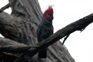
After breakfast we drove on a gravel road to the Heatherlie Quarry. This is a historical site where they quarried a lot of sandstone used in some of the buildings in Melbourne. There were the relics of the old quarry, some sandstone buildings and old derelict equipment, including a very large air compressor that was used to drive the hammers. As interesting as the quarry was the large flock of Gang Gang cockatoos. There were at least half a dozen of them screeching in the tops of the trees.
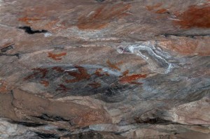
Next we went to the Gulgurn Manja Shelter site. This is a location where the aboriginal people used to live. It is a sloping rock that would give shelter from the rain, and there are many ochre paintings on the rock. The name “Gulgurn Manja” means “hands of young people” and there are many small ochre handprints there. As well there were paintings of emu tracks. From the rock ledge below the shelter you could see out over the valley to the north for many miles, so it would have been a good place to watch for other people moving across the plains.
We drove just a couple more kilometres and made our lunch to take with us as we hiked up Mount Zero. This walk isn’t very far, just a couple of kilometers, and it climbs to the 350 m summit of the hill. About halfway up there is a very narrow crack in the rock that you climb through. At one point it was so narrow that Enid and I had to turn sideways to get through, and I had to take off my small backpack. There is another way around, and we took that on the way down. You can see a very long way from the top of the hill in all directions. To the north are fields of olives. To the south are more of the Grampian hills. You can easily see the Gulgurn Manja cliff just a couple of kilometres to the east.
We then drove out to the western highway. At first we were on a very narrow and quite sandy dirt road. Somewhere along it we hit a tree branch, and knocked the mirror in flat on the passenger side of the motorhome (but did no damage). This joined a paved road of about seven kilometers, which was mostly a single lane of pavement. It was two lanes around the curves, but where it was straight, just the single lane, and both vehicles have to pull over onto the gravel shoulder when meeting.
We ran into many locusts once on the highway. They are about the size of our North American grasshoppers, but have bigger wings and seem to have a harder exoskelton as they make a very large noise when they hit the motorhome. We stopped for the day just across the Victoria/South Australia border at the caravan park in the town of Bordertown, and I took about half an hour to wash off the front of the motorhome. The locusts actually were quite a bit easier to wash off than I thought they would be.
Once again it was a cool day, though warmer here than it was in the Grampians. Many of our fellow campers are walking around in heavy sweaters and shivering. I however am wearing shorts and sandals and Enid is in her shortsleeves. It feels like a late August day in Saskatachewan.


