We didn’t have much information about El Malpais National Monument, but I wanted to go there as I had read that it had good hiking. We drove the approximately 40 miles south of Grants, New Mexico passing a few signs that said “El Malpais” but not seeing any signs that indicated what there was to do there. Finally we saw a sign that indicated there was an information center, so we stopped and got some advice.
The ranger suggested that we hike the El Calderon trail, so we drove back a couple of miles to where it started. They have closed all the caves because of white-nose syndrome, except for the Junction Cave, so we walked through that. It was a short lava tube of about 100 yards length, and quite rugged with old broken pieces of solidified lava that must have fallen from the roof. From there we continued past Bat Cave, which you cannot enter anymore, but where you could certainly smell the bat guano. About halfway around the hike is the El Calderon cinder cone, which is a crater about 50 m deep which last erupted perhaps 3000 years ago. It is surrounded by walls of reddish cinders, which I climbed to the top for a good view out especially over the valley to the east. While I was up on top, I spotted a man walking towards the crater with two dogs. One of the dogs bared it’s teeth and snarled at Enid, before the owner called it off.
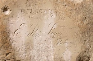
We arrived back at the car just before noon, so ate lunch as we drove on to El Morro National Monument. We had no idea what was there, but the ranger at the El Malpais station had said it had rocks with petroglyphs, so we thought it might be worthwhile. It turned out to be the third site we’ve visited unplanned (the other two being Hovenweep and Chaco National Monuments) which we’ve really enjoyed. There are hundreds of names carved into the sandstone cliffs here, starting with petroglyphs of the Zuni people, then the Spaniards in the early 1600’s, through to the middle of the 1860’s when American settlers stopped here on their way west. This was a stopping place for many people because there is a pool of water at the base of the cliffs, the only water for many miles of travel through the desert.
After looking at the carvings we continued on the trail to the top of the mesa. It was a climb of about 200 feet and on top after following a trail which skirted the canyon below we came to a Zuni pueblo site, Atsinna, which has been partially stabilized. The site was abandoned in the 1400’s.
It was fairly cold overnight, and there was frost on the windshield this morning; however, it warmed up through the day, and was a very nice temperature for hiking.

