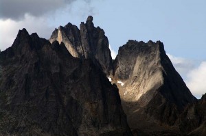
Today we hiked on the Grizzly Creek trail three kilometres in to the Mount Monolith viewpoint. That wasn’t our original plan. In one of our guidebooks it says there is a trail that starts from a gravel pit at kilometre 61.5 of the Dempster Highway. But there is no gravel pit at that location, and nowhere that would be possible to hike. We drove back to a pullout we’d seen coming south, but it was into a deserted private cabin. So we continued south to the start of the Grizzly Creek trail, arriving just at the same time as a tour bus. They let the passengers out and I thought we would be forced to pass them along the trail, but they didn’t go very far. We passed them in the first 200 metres, and I’m sure that’s about as far as they went. They definitely would not have been fit enough to do this trail.
The trail starts out broad and flat, and nicely gravelled. But almost at the point where we left the tour group, the trail becomes narrow and very rooted. It continues like this, fairly flat, as it follows the creek. At kilometer 1.7 it begins a climb. The first few metres of the climb are up a set of stairs, which I don’t quite see the reason for, as shortly the trail became steeper, and quite rugged, with several locations where there is a lot of broken rock, and there are no stairs for the rest of the trail. At kilometre two you rise above the trees that you have been walking in to this point, and can start to see east towards the Ogilvie Mountains. At kilometre three you reach a viewpoint where you can first see Mount Monolith. We ate lunch here, and then Enid lay down in the shade while I walked on another half a kilometre, and 50 metres more gain of elevation, to a total height of 1420 m. This makes the trail quite steep, as it has gained about 400 m of elevation in the last kilometre and a half before the viewpoint. From this higher viewpoint you get a sweeping view across the valley towards Mount Monolith.
As we ate a group of about ten German speaking hikers went past us. They stopped to eat at the top of the ridge, and they were just leaving as I got there. On our way down we saw quite a number of backpackers hiking in with heavily laden packs. Two of the hikers were young park rangers. This would be a difficult backpacking trip, as the climb is steep, and you are only half way up the altitude gain at the viewpoint.
Once down the trail, we drove back towards the campgrounds, and found a gravel pit at kilometre 67.5, so we assume that it is a typo in the tour book. We may go there and do some more hiking tomorrow, or we may just go into Dawson.

