We spent today along the Nabesna Road, an old, not very developed road into the North end of Wrangell – St. Elias National park and preserve. Here the high glaciated mountain volcanoes of the Wrangell range are on the south of the road, with the lower Mentasta mountains to the north.
Just shortly after leaving our campsite we got our first glimpse of the 16000 foot high Mt. Sanford. To its left is the lower active volcano of Mt. Wrangell. Although we could occasionally see the tops of the mountains above the clouds, they were not always clearly visible. The glimpses of the glaciers and ice-capped mountains were spectacular.
We started the day with a hike up the Caribou Creek trail. This trail is a bit over 12 kilometers return, and climbs about 300 metres. The lower part of the trail has been heavily gravelled which gave way under foot, so was somewhat hard to walk on. Then the trail crossed an extensive muskeg area. As the trail is also used by ATV’s (though it is now closed because it is so wet) this part was quite cut up. However, there were trails around the worst parts that people have made, so it is easily passable. At about 3.5 km you cross Caribou Creek, not very hard as it was only about 6 inches deep. Later on you cross it twice more. At the end of the trail is a very nice new cabin, with two wooden beds, and a stove. We were expecting to see a ramshackle old building, as that is what is described in the guide. However, this shelter has just been newly constructed, and from the log book in it, not too many people come to use it. From the balcony of the cabin was a very nice view out south towards the Wrangell mountains, but unfortunately the tops of these were mostly cloud covered.
After we’d eaten lunch there we walked back down and then drove up the rest of the Nabesna Road to its end forty miles inside the park. Along the way we saw many nice views of both mountains to the north and south of us. There are several streams to cross, but only the first one had water running, the rest were completely dry. They are pretty rough however, as the crossings are very rocky, so we went slowly to avoid damaging our tires any more. We really didn’t want another flat away out here!
The guide says there are “several” campsites at Jack Creek, mile 35. However, we could only see two, and one was occupied. We set up our tent to claim the other, then drove on to the very end of the road. We crossed a few more dry stream beds, and then reached a tiny airfield with a few houses. There were some very small planes there. We saw a couple of backpackers hiking back to their vehicle, and carrying a shotgun. Yes, strange as it may seem to those of us in Canada, you can carry a gun in this park. You can also subsistence hunt (you can do that in Kluane too if you are First Nations, but here anyone can do so). On the way back we stopped at one of the streams and picked up a bunch of wood, as there isn’t any at this primitive campsite. Two park rangers passed us while we were tying it on the roof, and waved, so I guess it’s OK to scrounge wood like that! Just before supper tonight we heard several rooster crows. There is a house a bit back a few hundred metres from here across the creek, so they must have chickens. Later we heard several rapid gunshots, much to fast to be target shooting, so they must have been shooting at something. The campers on the far side of the road have left, (and they left their fire burning, so Enid put it out) so now we are quite isolated out here.
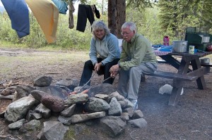
It was quite cool and windy as we ate supper. Since there is a nice fire pit here built out of lava rocks, and we had collected wood, we decided to have a wiener roast and did our sausages that way. Enid also roasted a couple of marshmallows after supper tonight. The wood I collected turned out not to be too good. Although it is cured, it has also been in the water for a long time, so the interior is wet. The smaller wood that Enid picked was better. The wind has stopped, but there are still lots of clouds, and a few sprinkles of rain have just finished.

