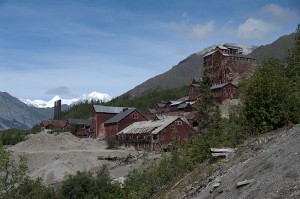
Today was a wonderfully sunny day. There were some clouds, but not enough to obscure the glaciers on the mountains as we drove the long and rough road into McCarthy and the Kennicott (or Kennecott – no-one seems certain how to spell it, and you see signs with both) mine site. Our first glimpse of the mountains was just as we left our campsite, as both Mt. Sanford and Mt. Wrangell are easy to see from the road. There is a massive icefield on Wrangell. Yesterday it was so overcast and cloudy that we had no idea the mountains were there.
The road to the town of McCarthy is sixty miles long, just wide enough in most places for two cars, though when meeting other vehicles you both must pull completely over. There are several spots that are single lane only, including a narrow cut through the rock just as you leave Chitina, as well as several of the bridges. The road follows the old railway line into Kennicott, and at many places there are visible signs of old railway ties and occasionally complete rail lines embedded in the road. The first five miles are very narrow and rough, as are the last fifteen – really full of potholes so that the Yukon rattled and shook along even at ten miles per hour. It took us an hour and forty minutes to drive back, with no stops.
In the morning we did stop a lot along the way. The first was at the Copper River. There is a large flat area just after crossing the bridge. Here there are many fish wheels set up. As well there were a lot of fishermen using dip nets. These are very large nets on long poles, perhaps twenty or thirty feet long. Any Alaskan can dip net for salmon, and there would be no other way (other than the fish wheels) to catch them in the extremely silty water. The Copper River is one of the most silt laden rivers in the world, so the water obscures the nets and the wheels and makes it an effective way to catch fish.
Our other stops along the McCarthy road were to photograph the high ice covered peaks of the Wrangell Mountains to the north. On a map you can see that most of the interior of Wrangell – St. Elias National Park is covered with ice. From the road you only get occasional glimpses of these high mountains in the interior, but when you do they are impressive. Since the road is at an altitude of 300 to 400 metres, but the tops of the highest peaks rise over 4500 metres, they stand out spectacularly high.
At the end of the road is a small footbridge and a few parking areas to leave a vehicle. The closest ones cost five dollars, so we parked in one about half a kilometre from the river where it was free, and walked to the bridge from there. We crossed the bridge, and since a shuttle van arrived just as we got there, made a spur of the moment decision to go into the town and up to the mine site at Kennicott. This was only twenty dollars for the two of us, but it was a very slow half hour ride over the potholes to the mine site. We’re happy we went, as it was an interesting site to see.
The mine closed in 1938, but the buildings and much of the machinery was just left there. No environmental impact studies in those days! The National Parks Service is restoring some of the buildings to show them as they were in use. We didn’t spend a lot of time, just over an hour walking around to the buildings that are open. It was fascinating, and there are great views out over the moraine at the end of Root Glacier, up to the glacier icefall, and on into the mountains in the distance.
There really isn’t anywhere to camp along the entire road, so you would either have to stay in the Glacier Lodge, or if you had a motorhome (but who would want to bring one up this road) you could stay in the parking lots overnight for just five dollars. There may be a hostel or some other site here, but I didn’t see it. We didn’t plan to stay anyway, so left the bridge parking area just about 3:20 and got back to the town of Chitina by 5:00 pm, driving as fast as I could on this road without shaking the vehicle apart. Since it was such a nice site we had yesterday we are once again camped in exactly the same location at Liberty Falls.

