Today we hiked from Alberta to British Columbia! Well, that distance wasn’t too far, just about two kilometres. Our destination was Wall Lake which is a quite nice walk into the Akamina-Kishnena provincial park. The trail climbs until you reach the Alberta-British Columbia border, then it is quite level from there approximately another four kilometres to Wall Lake.
We started our day with a drive to Cameron Lake, which is not far beyond the Akamina Pass trailhead. This lake has boat rentals, but early in the morning it wasn’t very busy, and is a very pretty lake nestled below towering mountains. We met the German couple there who had been on the International Peace Hike with us two days ago. They were going on a guided hike up to Summit Lake. We however returned to the trailhead.
There were two men and a woman getting ready to go hiking (at least we thought all three were going, but only the two men actually were on the trail). As I’d neglected to bring the park map, we weren’t sure if this was the right trailhead to Wall Lake – in fact I couldn’t even remember the name of the lake – but these people had a rough map, so I could see that this was where we wanted to start.
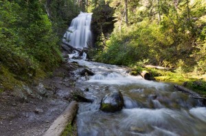
There were very few wildflowers along this trail. However, there is a very nice waterfall, Forum Falls, which is just a little over 200 m off the main Akamina trail. It was very cool by the falls, a relief as it was another very warm day. There is a campground just a short distance past the falls junction on the main Akamina Pass trail, followed almost immediately by the junction to Wall Lake. You cross the creek, and then it is a fairly level walk into the lake. The lake is not large, maybe a kilometre across, and completely surrounded by high rock cliffs rising sheer a thousand metres above the lake. There was a slight current in the lake, which we could tell from the moving pollen covering the water, as well as some logs and ice floes that were drifting towards the exit stream.
There were a great number of downed trees along the lake shore. Many of them were very large trees, half a metre in diameter, and they were all snapped off several feet above the ground, or else directly uprooted. They had very recently been cut through to reopen the trail. We followed the trail towards the end of the lake (and the toilet) but that was as far as we could go. Beyond this they had not cut the trail, and it was a tangled mess of downed trees, and old snow banks, so it looked very much like an avalanche.
We ate lunch back about halfway from this point and then headed back. Just as we rounded the first bend after leaving the lake, we came across a young park ranger. He had a can of gas that he was loading into a backpack, and a mountain bike. We talked to him and found that they had just cut out the trail on Friday, and the gas had been stashed in the bush. He said they were not sure what had taken down the trees, but though it was a class 3 or 3 ½ avalanche. They thought that perhaps an entire cliff of snow had broken free right to ground in the late spring. The power of the avalanche must have been tremendous, as it is almost a kilometre across the lake from the base of the cliffs where the avalanche would have landed.
It was very hot in the afternoon. We refilled Enid’s water bottle at the creek before leaving the lake, and the water was lovely and cold. Then we filled it again when we got to the Akamina campsite. The water was excellent and what was left made much nicer tea for supper than the heavily chlorinated water here in the trailer camp.


