November in Prince Albert

image

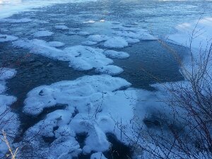
The rapids near the airport

We became reverse Snowbirds this fall,
returning just as it began to snow.  It has been a beautiful November for outdoor winter activity, with enough snow that  we have been able to do a great deal of snowshoeing and cross-country skiing.

This  afternoon I snowshoed down to the rapids across from the airport. It was another bright sunny day with a temperature about -15 C and almost no wind. Although most of the North Saskatchewan River is frozen, it isn’t very solid yet. It was a bit nervewracking to walk on the ice (right by the shore though, so I did feel safe) and occasionally hear the ice crack.

Posted in Miscellaneous postings | Comments Off on November in Prince Albert

The Missouri River, October 23

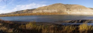
The Missouri River

We are camped tonight in James Kipp Recreation Area, a BLM site in Montana along the Missouri River and Highway 191.  There are about thirty campsites here, and it is reasonably busy, perhaps 1/3 full, which is interesting, as it is also quite chilly.  I assume the people here are probably hunting, as the sign near the registration booth said mule deer season ends on November 11.The temperature is very close to freezing, and sometime in the past few days it has snowed in the hills.  There is no snow here, but there was on the low mountains which we drove by.  We will have to drain our water tank and will winterize the trailer tomorrow before we leave.This will be our last day in the US.  Tomorrow we will cross the border close to Val Marie.  The highway here is quite good, a two lane road with not a great deal of traffic.  It doesn’t have a very wide shoulder, but the pavement is reasonably good.  There also aren’t a lot of towns or gas stations.  We filled up in Roundup, Montana, saw a gas station in Grass Range, and the next one will be in Malta, about another 100 km along the road.

Posted in Going South, 2012 | Comments Off on The Missouri River, October 23

North we go, October 22

Well, we are definitely heading north.  The temperature dropped all day as we drove to Casper, Wyoming along I 25.  It was about 17 C at noon and now is about 10 C tonight.  Part of that is due to the weather, as we drove across a front today.  It started out very windy, mostly from the south, and we could see a high altitude bank of clouds across the Rocky Mountains to the west of the highway.  Gradually the clouds became thicker as we drove north, and it really cooled off between Cheyenne, Wyoming and here.

Tomorrow we head towards Billings, Montana, then north through the back country of Montana.  I checked the route on Google street view, and the road doesn’t look too bad.  I also checked the location of the gas stations, as there aren’t al lot out there.  We probably will stay at the Kipp recreation area on the Missouri River tomorrow night.  I doubt that we will have either Internet or cell phone coverage until we get back into Canada once we leave the Interstate at Billings.

Posted in Going South, 2012 | Comments Off on North we go, October 22

Cheyenne Mountain State Park, October 21

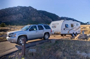
Cheyenne Mountain State Park

We left White Rock, New Mexico this morning, and drove south at first towards Santa Fe, then followed Interstate 25 north to just south of Colorado Springs, Colorado.  We are camped high up on the side of Cheyenne Mountain, just below the NORAD headquarters buried in the mountain.  Tonight we can see bright lights not far away from us lighting up the side of the mountain in two spots, so perhaps they are where the access tunnels are located.  Hopefully no nuclear war starts tonight, or we are toast!

We went for a short hike when we arrived.  It was very warm out today, up to almost 80 F, and though it has cooled off now rapidly, it is still nice out.  We had a campfire and burned up our wood tonight as we didn’t want to haul it with us any further, and roasted smoked sausages for supper.  It is Enid’s birthday today, so we had the carrot cake we bought yesterday to celebrate.

Posted in Going South, 2012 | Comments Off on Cheyenne Mountain State Park, October 21

Frijoles Creek Upper Falls and Frijolito Ruins Trails, October 20

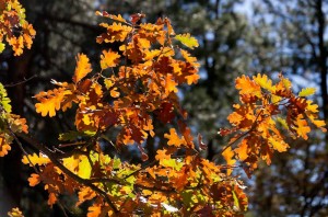
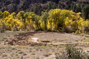
Fall colors, Gambel Oak

It was a very nice fall day as we walked the trail down from the Bandelier Visitor Center to the upper falls of Frijoles Creek.  The fall colours, gold of the cottonwoods, reds of the gambel oaks, the dark green needles and red bark of the ponderosa pines, combined with the perfect temperature to form a beautiful hike.  The results of last fall’s flash flood are still highly visible, as there is thick black mud and sand in the creek bed covering many downed trees.  The two bridges on the route are just temporary planks, one cut from a tree, and the other made of lumber.  You cannot travel past the upper falls, though the trail used to go to the Rio Grande river, since that part of the trail was completely destroyed.

After lunch we hiked uphill to the Frijolito Ruins.  This is an unexcavated site of an old pueblo.  There isn’t much more visible than a few piles of rocks.  Since there isn’t any ice or water here to push rocks around, there could be little other reason for the rock piles to be there.  Along the trail we could see very clearly the size of Tyuonyi Pueblo, Long House, and Alcove House across on the other side of the canyon, which we visited two days ago.

When we got back to the visitor center we drove to the White Rock Overlook.  Every bus driver we travelled with told us to visit it, and it is a spectacular mesa top view of at least 270 degrees out over the Rio Grande River far below at the bottom of the canyon.

We are writing this in Timeout For Pizza, where we are celebrating Enid’s birthday.  There aren’t many restaurants here in White Rock, and this one is right across the street from where we are staying.  Unfortunately tomorrow we “officially” start home as we plan to head north into Colorado, and then it will be drive, drive, drive home.

Posted in Going South, 2012 | Comments Off on Frijoles Creek Upper Falls and Frijolito Ruins Trails, October 20

Los Alamos, October 19

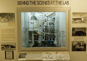
Los Alamos Historical museum display

It was a day in both the past and the present.  We rode the free bus in to Los Alamos this morning, arriving before any of the museums opened, so we just walked a bit and then stopped at Ashley Pond (which should really be “Ashley Pond Pond” as it is a pond named after Ashley Pond) in the historical part of the city.

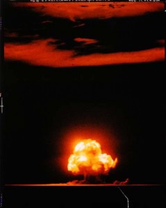
 When the museum opened at 10 am we toured the historical museum, which is small, but crammed with exhibits and a lot of text to read about the Los Alamos area, both before the war, but especially of the reflections of people who lived here during the Manhattan Project.  There was an exhibit of the work of by Jack Abey called “Jack Aeby: His Life and Work Beyond the Blast” and coincidentally there was an individual filmmaker there shooting a documentary about him.  He was one of the photographers that worked filming the Manhattan project, and took the only color photos of the Trinity test explosion. 

Trinity Bomb Test
Photographer: Jack W. Aeby
© Time Inc.

He is now 89 years old, but it was interesting to hear him speaking to his daughter about his thoughts about the past.  His biggest complaint was that many copies of his famous picture of the explosion are printed backwards (including this one which is from the Time-Life collection).

Perhaps my most disturbing thought about the museum has to do with the process of aging.   The equipment they were displaying that came from the project chemistry labs was far too familiar, consisting of things that I used over forty years ago.  This equipment was closer in age to the equipment I used to complete my Ph. D. than todays equipment is!

After lunch we walked to the Bradbury Science Museum, which is funded by Los Alamos National Laboratory.  Some of the history section was a duplicate of what we saw this morning, but the displays about their modern research were very interesting and well done.  On the way back on the bus we coincidentally met our campground neighbours, who are from BC.  They too had spent the day in Los Alamos.  Both they and we had the impression that Los Alamos is not a town that is short of money!

Posted in Going South, 2012 | Comments Off on Los Alamos, October 19

Frijoles Canyon, October 17

Tyuonyi Pueblo

We left Albuquerque this morning and drove to the small town of White Rock, New Mexico, which is just south of Los Alamos, and the entrance to the Bandelier National Monument.  Our plan was to camp in Juniper Campground inside the monument, but when we got to the visitor center we discovered that as part of their brand-new building they have opened an RV parking lot complete with water filling station, dump station, and electric power at each site.  When I asked the attendant in the visitor center how much it was she replied, “since they haven’t got the pay station up yet, it’s free.”  That sounded like a good deal to us.

So we ate lunch, and then took the free shuttle bus in to the canyon.  Since they had a fire and flash flood last year they are not allowing private vehicles in to the park.  Instead you must ride a bus that runs at a very convenient interval of twenty minutes.  The bus driver also acted as tour guide and pointed out many things along the way associated with the history of the area, and the Los Alamos National Laboratory.

At the park itself we walked around the main tour loop and saw pueblos, and perhaps a thousand places where there once were rooms along the cliffs, sometimes three or more stories high.   In many of these spots the ancient people dug caves into the soft volcanic tuff as part of their residences.

At the end of the trail we climbed up 140 vertical feet to Alcove House.  This entailed scaling four ladders three of them between 30 and 40 feet in length, and some very steep steps.  Enid made it to the top, even though she found it pretty nerve racking!

We plan to stay here for at least one more night, probably two.  Tomorrow we will take the free bus into Los Alamos, and tour the free museums.  Free transportation, free accommodation.   That’s hard to beat!

Posted in Going South, 2012 | Comments Off on Frijoles Canyon, October 17

Old Town Albuquerque, October 17

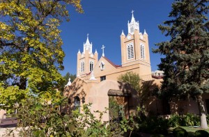
San Felipe de Neri Church

We went in to the area known as “Old Town Albuquerque” this morning, and parked in the Museum parking lot.  Since I didn’t have the necessary five dollar bill for parking, I went in to the museum to get change.  The clerk said that if we were going to be visiting the museum, the parking was covered, so we got in for four dollars, saw the museum, and parked for the morning while saving a dollar.

We went on the walking tour of the old town using the brochure from the museum.  Most of the old buildings have been converted into specialty shops, restaurants, etc.  However, the old church which was first constructed in 1706 (though it has been rebuilt and remodelled several times) was open, so we went inside to see it.  It is not a very large church, narrow with only two rows of pews.

They were doing a filming production on the streets around the plaza.  We passed a sign that said it had the working title of “American Girl – Alberta”.  What they were filming appeared to be a parade scene, so they had a lot of extras along the streets, and the signs said that you agreed to be in the film if you were photographed.  Since we really didn’t want to be included, we tried to stay inside the stores while they were filming.  The stores were not very busy as most people were on the street watching. 

The star, a young girl, was riding on a beautiful grey horse.  However, she was very uncomfortable on it, as you could see from her expression.  Two men were actually leading the horse with monofilament fishline, which you could see close up, but probably wouldn’t show in the filming.  There was a stunt double there who also rode the horse and was obviously a good rider.  We stayed and watched the production for a while.  It involved a very large production crew.

At the end of our walk around the old town we went back to the museum.  They were remodelling it, so parts seemed to be closed.  We did see an exhibit called “Machine Wilderness” which highlighted art and technology, “Along the Rio Grande” which is about the history of the Albuquerque area, and their permanent collection “Art in New Mexico”.  After lunch across the street in “Tiguex Park” we returned to the museum to finish our tour.

Posted in Going South, 2012 | 2 Comments

Petroglyphs National Monument, October 16

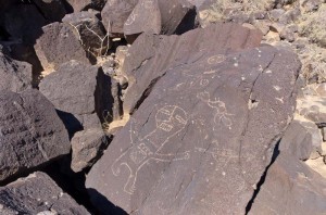
Piedras Marcada Canyon petroglyphs

We spent the morning looking at some of the petroglyphs inscribed into the rock varnish on the basalt rocks of Petroglyph National Monument.  We had expected to see a few.  That is an understatement, for there were hundreds of them.

These petroglyphs were mostly carved by the ancestral puebloans; however some of them are more modern than that including petroglyphs by the Spaniards and others.  After we had seen those in the Boca Negra Canyon we drove north about six miles to the Piedras Marcadas Canyon where we walked about a mile and took far, far too many pictures.  I’m not sure how many pictures of petroglyphs I really need!

After lunch we went shopping.  We found a very large mall not far from where we had been viewing the petroglyphs, and spent the afternoon walking through the stores there.

Posted in Going South, 2012 | Comments Off on Petroglyphs National Monument, October 16

Albuquerque, New Mexico, October 15

No picture today, as none was taken.  That must almost be a first on this trip!

We drove here today on I40, a not too busy interstate, and stopped at the Camping World store where we bought a few things we wanted for our trailer.  Then after setting up in the RV park we drove to REI where we took part in our favorite activity: shopping for outdoor clothing and supplies.  I bought a new pair of hiking boots (tried on six different brands and sizes, so I hope the ones I got are good) and Enid got some new clothes.

We will be here for two more days, then we will be starting on our journey north.

Posted in Going South, 2012 | Comments Off on Albuquerque, New Mexico, October 15