
Wapumon Gorge
Not sure why we were a little bit slower today, as we got up at the same time, it was beautiful, warm and dry, but we didn’t get on the water until 8:40.
It is another beautiful evening. It was almost too hot at supper time as we were eating on a rock shelf facing the west. The sky was very hazy, and it looked as if there might be a storm; however, the sky cleared later on. There is almost no breeze. The bees are buzzing loudly in the absolute still evening as they seek out the bluebells and wild mint near me here where I am sitting on a rock.
We got to the first portage at the gorge, after running down the small rapids on river left (13 U 628150 6159022) by a small island. There is a very obvious bay (13 U 628573 6158747) to pull into above the upper major rapids (you can just see them around the corner). This trail was in poor condition, not very visible, but there was an old rotted boat at the start, barely there anymore, and the remains of an old pole skid. I walked across the short 100 m trail to confirm that it was the correct one. At the end was a newly fallen poplar blocking the trail, so I told Graeme to carry the food box first, and I would saw off the log. This portage ends in a very narrow bay that opens up into a larger bay about 400 m above the gorge. Again you can just see the bottom of the first rapids, and the start of the gorge around the corner. If you didn’t know what was there it could be very dangerous to go that way!

The correct trail for the Wapumon Gorge
We pulled in to an obvious trail (13 U 628909 6158648) that ended at a small rock. We unloaded, and started up the trail. After about 30 or 40 m it started to peter out, and was soon completely gone. Foolishly we didn’t stop and look for the correct trail. I assumed that the trail was just so little used that it was not very visible. Occasionally you could see small traces of a trail. We walked up a steep hill to the top of the cliff, and then had to come down again. While I got through ok with a pack, it was hard work, and Graeme had extreme difficulty and was very tired by the time he got to the end. Essentially he just powered his way and bushwhacked through the trees. At the end it got to be too rough and he had to drag the canoe. He never dd get to the water, but eventually found the proper trail. He left the canoe where he found the trail and followed it back. It was a much better trail. Though not well used so not very visible, it was much flatter as it skirted to the north of the large hill that forms the gorge. We found that it started in the end of the bay not more than 20 m from where we had left our gear. We took the second load across that way, and it was very, very much easier. What we had started following was just a beaver trail.
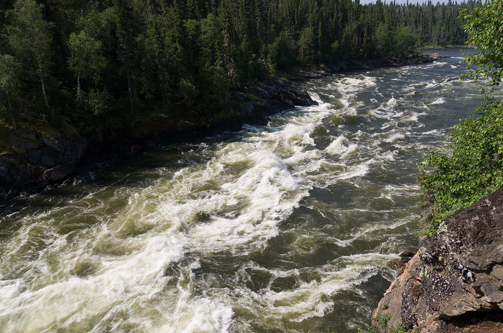
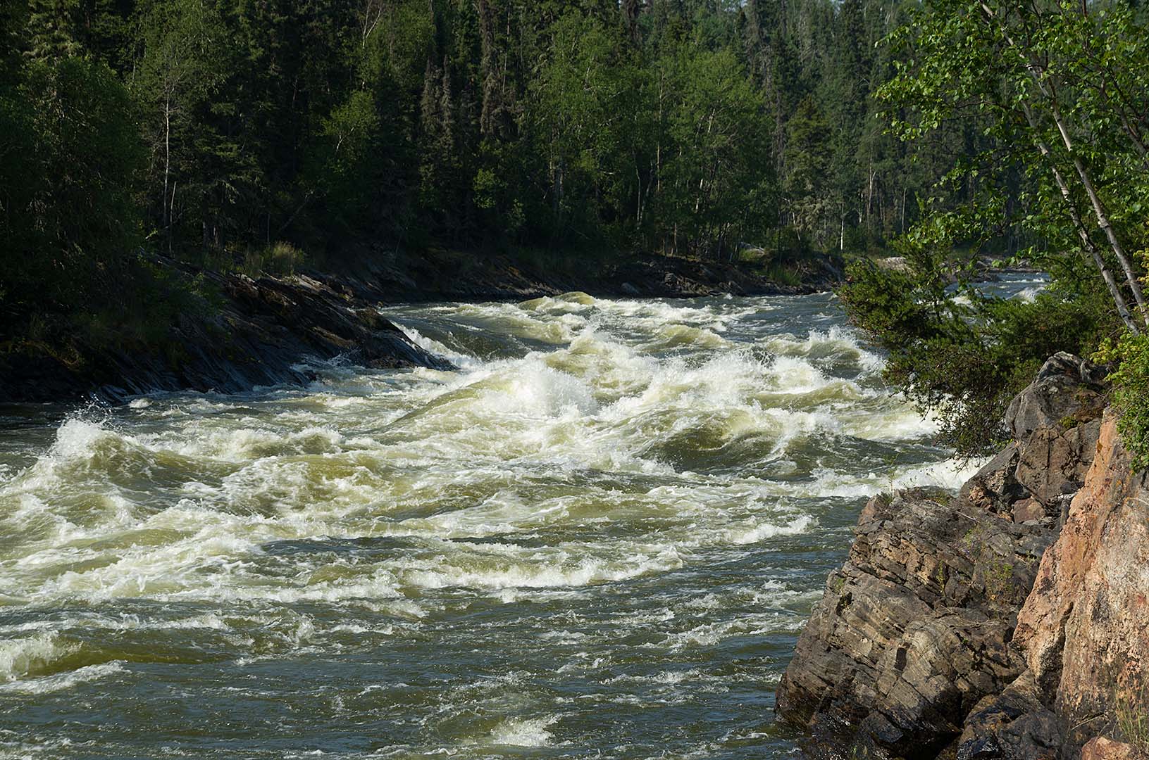
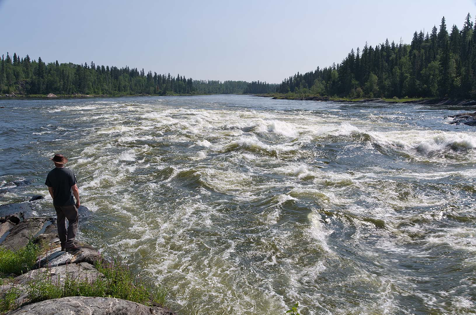
Wapumon Gorge
We did a lot of photography at the gorge, which is spectacular as all the water of the combined Churchill and Reindeer rivers squeezes through a narrow channel about 20 to 30 metres wide. There is also an enormous ledge at the top river right of the drop. Squeezed in by canyon walls, it is one of the most impressive rapids I’ve ever seen. At the end there is another large drop and huge standing waves and eddies, and an enormous surge that makes it difficult to load the canoe.
Below the Wapumon Gorge
We did get the canoe loaded but about 100 m below the loading spot is a long rock ledge that sticks out into the river channel. I was worried that there might be a lot of current over the edge of the ledge, and it looked as if we could get through gaps in the rock ledge without having to go out into the main flow. so we tried that. Unfortunately it is really too shallow, and the pressure surges vary the level by two or three feet. It looked as if we could get over, but instead the water drained back, and left us hung on the rocks. Then the next pressure surge hit us sideways and since we were wedged on the rocks, it mostly came into the canoe. We got a lot of water in on the first and then two or three more waves hit us. Graeme and I both got jumped into the water and lined the canoe as best we could, though it was often stuck on rocks. We finally got it to the ledge and saw that there was not enough water to get through the breaks. Instead we lifted the canoe over, after first bailing out the water.
Not far below this ledge is a rapids (13 U 629587 6158673), though it is not difficult and we ran it easily. At first we thought we would go close to the right shore, but what looked like a smooth V was actually a shallow ledge, so we had to ferry hard tot he left to avoid this. The fast water divides and goes around a large island. We went to the longer right hand channel, but that is where the majority of the water flows. There is a rapid near the end of the island (13 U 630453 6159151), about class 1, and it doesn’t really end much before you reach a larger rapid (13 U 630057 6159531). This was easily navigated as we started on the river left, then crossed all the way across to the right to avoid the small ledges.
After finishing these rapids we stopped at the point marked as a campsite on our maps. We took off our boots and socks here. I was surprised that mine weren’t as wet as I expected them to be. There is a lot of fast water in this area, and it sounds like major rapids as we ate our lunch, though none of them were difficult to navigate. We continued to run several minor rapids near the narrows at the end of Wapumon lake, were it swings to the north.
Since it was calm we had an easy paddle across the width of Wintego Lake. We stopped at a large island. To the south of the island we could see a fishing camp. There appeared to be either a very tall tree or an antenna. We can’t see it from here though. We have a nice spot for our tent, though I think that there may be a lump in the middle so we will have to figure out how to sleep while avoiding that (there was a huge rock, we tried to avoid it, but had a generally miserable night’s sleep).
Because our packs were wet from the waves at the gorge, we dumped them out and let things dry. Graeme said it was our first gear sale of the trip. We swam in the afternoon heat, which felt really nice, then went fishing. After an hour only Graeme had caught anything, so we didn’t have enough for supper. I said we should take out the canoe, and we went a few hundred metres up the shore. Here I had two fish on, but didn’t land either one. Then I thought that I had some weeds, so just reeled them in and as they approached the canoe could see that I actually had a fish. About the same size as Graeme’s but much smaller than the last couple, it was good to have two for supper.
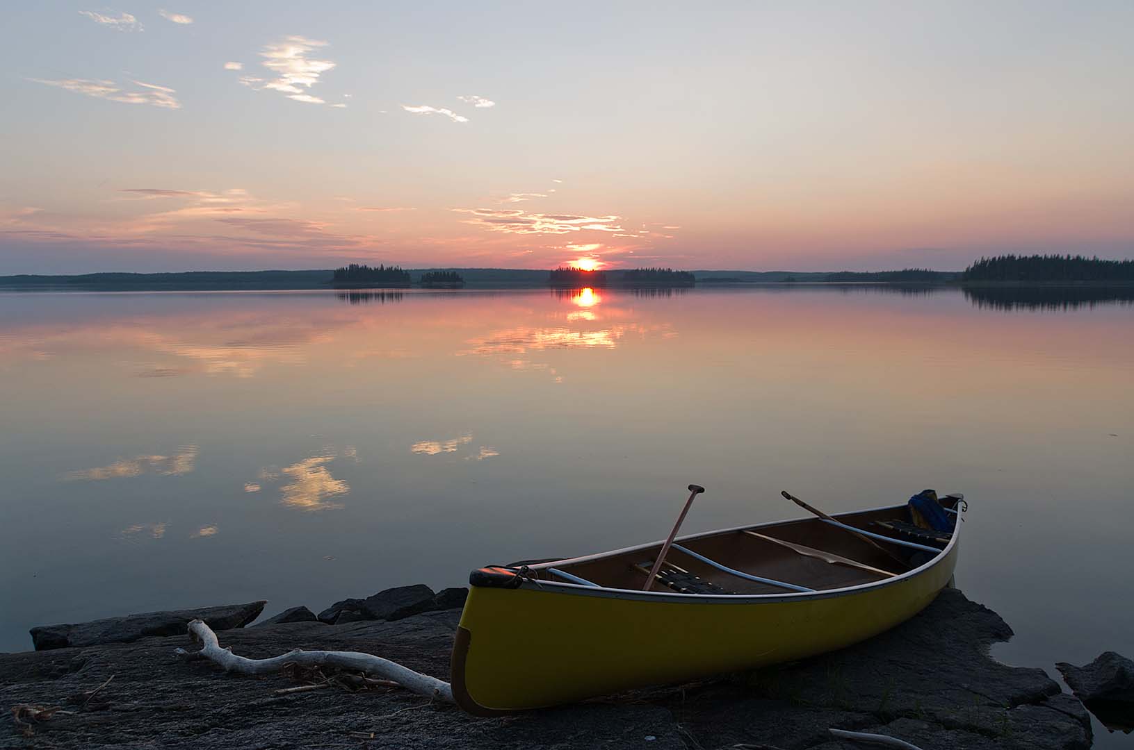
Sunset on Wintego Lake
After supper I baked our first two bannocks. They will now be cool so it is time to put them away. There is hardly a cloud in the sky, just some haze on the far western horizon as the sun is about to set.
Paddled 16.44 km
Camped 13 U 0636279 6161106 (NAD83)
Pingback: Hiking in Banff National Park - David and Enid's TravelsDavid and Enid's Travels