Death Valley is stunningly beautiful. Strangely it is a land shaped by water, yet water hardly exists within it. The valley floor is mostly the remains of old and dessicated lakes, while the surrounding rugged mountains are sculpted into crags and eroded valleys by occasional but rare floods of water. Over thousands of years they have left their marks. With almost no intervening water erosion, the scars left by water in the past stand out everywhere.
There are almost no plants, except for the occasional salt tolerant bush like Desert Holly. The ground looks like the aftermath of some gigantic fire, yet there is almost nothing here that would burn.
This morning we were amongst the first, if not the first visitors to the historical ruins of the Harmony Borax Works. Here there is a short interpretive trail around the old 20 mule team carts, the boilers and troughs where the borax was crudely refined, and remnants of old buildings. We drove out on the Mustard Canyon road, aptly named for the yellow coloured dirt that makes up the walls.
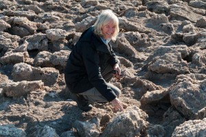
We drove south towards Badwater, stopping along the way at the Devil’s Golf Course. Here at the northern end of Badwater Lake are very rough and rugged salt deposits. It looked like dirty river ice that has just broken up and piled along the shores. We kept repeating that it looked like it should be cold and slippery, but it wasn’t of course. It was very hard and jagged and tough to walk over.
At Badwater there is a very small amount of open water with salt crystals floating in it. The small pond of water reflected the high rock walls of the mountains on the east side. Almost a hundred meters over head is a sign that reads “Sea Level”. This is the lowest place in North America. We walked out for at least a kilometer onto the salt pan. So many people have walked on the salt that the crystalline structure is flattened out, until you get a long way out onto the dry lakebed where you can see the ridges the salt crystals have formed. Once again we commented that it looked like dirty ice, and we expected it to be slippery. It wasn’t.
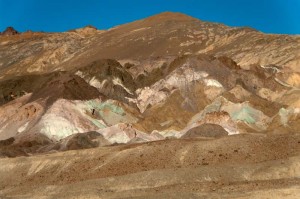
We ate lunch, then hiked in about 2 kilometers to the Natural Bridge. Next we drove the Artist’s Drive road, a one way paved road for several miles that rises up to beautifully colored rocks – chocolate browns, reds, greens and yellows. One point called the Artist’s Pallette is particularly spectacular with bright colors.
By now we had walked quite a bit, mostly just short walks of a kilometer or so, but enough that we were both tired. However we decided to go on one more hike into Golden Canyon. It was about 4 kilometers return, and rose almost one hundred meters, but it seemed like an easy walk. It was worthwhile, as the rock walls of the canyon were carved into many stunning shapes, and golden colored in the late afternoon sunlight. The grade was not too steep, in fact, it used to be a paved road, but it washed out in a flash flood in 1976. Remnants of the pavement existed in a few spots. It reinforced how much of a role water has played in shaping this arid desert.


