Sometimes just doing what happens is a good thing, and that’s how it turned out today. We first drove to Four Corners, which is an interesting enough location, particularly when you realize how the surveying of the original boundaries of Utah, Colorado, New Mexico and Arizona were originally carried out more than one hundred years ago. The inaccuracies in the survey were really quite slight, given the technology in use to make the measurements. Today using a GPS you can see how the actual spot is not where it was intended to be, but has nevertheless been adopted as the legal location based on the original survey. So on an accurate map, there is a slight bend in the boundary of Utah and Colorado to make it meet at the Four Corners.
It is an interesting spot, but not one where you’d likely return to (though for Enid, this the second time, though separated by almost fifty years). After we left there we weren’t sure where we would go next. Marked on the map just outside Cortez is Yucca House National Monument, but we had seen no highway signs on our way to Four Corners this morning. We tried to find information about it in our tour guides we’ve picked up along the way, but found nothing. However, we did see that there was information about Hovenweep National Monument, so we decided to go there.
That was our good fortune. It is a very interesting spot with a large collection of ancestral puebloan houses on the mesa beside a small canyon. The buildings are in very good condition, considering they are about 800 years old. There are many towers here, both square and round. The stone work is well done, and though it has survived well partially because of the extremely dry desert climate, it is also indicative of the quality of construction done by these ancient people.
We had two options when we left the visitor center to return to our campsite in Mesa Verde, as we could have either turned right or left, both indicated as 42 miles to Cortez on the road sign. The GPS route said go right, so we did, although on the map it looked liked the poorest road. While it wasn’t a great road, it was paved all the way. A few miles down the road we saw a sign pointing down a dirt trail to “Painted Hand Pueblo”, so we decided to see what was there.
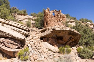
That was our second lucky decision of the day. There we found another very interesting tower pueblo and this one had very faint hand print pictographs in a rock alcove with some remaining walls, that once would have been a room below the tower. The trail down to the tower was fairly rough and undeveloped, but Enid says if there are pictographs and ruins to see, she doesn’t mind a bit of rock climbing and scrambling!
We also discovered that there is a lot of irrigation and farming as we drove back to Cortez. We passed may fields of alfalfa that were being cut and baled in huge square bales. There is an enormous contrast between the dry red desert soil and the verdant green of the alfalfa where it has been irrigated. It does show that the soil could produce for the ancestral puebloans when they had water, but that drought was probably the enemy that drove them from this area.

