A long day of travel, as we covered over 475 km. We didn’t plan to go that far today, but more on that later.
It was another beautiful sunny day as we set off this morning from the Tombstone Campground. We stopped at several sites along the way to take pictures and video, and enjoyed the spectacular arctic scenery. The vistas are incredible, as one can see for a hundred kilometers in all directions from the tops of many of the high plains. The far distant mountains form a blue backdrop to the tundra plains.
As we passed the Ogilivie River we could see why the road has been closed. There was evidence of a good deal of flooding, but by now the water has dropped. There were crews working on the road in several places. Parts of the road have been washed out, but the river is now confined to its streambed, though it is still running very high and fast.
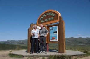
By late afternoon we’d passed the Arctic Circle sign (which according to my GPS is about 2 km north of the actual site), and had reached our planned destination of Rock River campground. We pulled in right behind a camper van, and chose a site. We set up everything, including our kitchen shelter tent as we thought there might be a lot of mosquitoes here. I went and got some water from the creek. It was somewhat turbid, probably from all the rain, but good enough for washing. Enid went and registered the site. As she came back she said “there’s no one else here. The others didn’t stay.”
We sat in our camp kitchen shelter for a while. I was reading the instruction manual for the generator to see when it needs an oil change (soon). I’d set up the barbeque, and we were just getting ready to start supper, when Enid heard a cracking sound in the bush, said “I hope that’s not a bear” and turned around to see that indeed it was! It was a small black bear, which disappeared when we yelled, but we decided not to stay here. We quickly packed everything up, and headed off down the road again, to the next closest site (this one) which was about another 80 km down the road.
Along the way we saw a couple of herds of caribou. We also stopped at the NWT boundary and took a picture. There is quite a bit of construction between the border and the Peel River crossing, so the road here is quite rough. We reached the ferry just as it was about to leave, but he waved us on, so we didn’t have to wait at all (though we’d had to wait earlier for a flagman at the construction). We then arrived at this campgrounds, and went to register.
We chatted with the caretaker a bit while we registered. He said that he was surprised the ferry was still running, as the river is flooding. There definitely was a strong current and a great deal of flotsam as we crossed today. He also said to take campsite 17 “as it’s the closest to the showers.” Showers!!! We had no idea they had them here, and what a wonderful clean building they are in. Though it’s the most expensive campground we’ve stayed in at $22.50, it’s by far the nicest from that standpoint, as it’s the first one we’ve been in with running water.
This is the same campground as we stayed at in 1997, where they had the tables made out of huge logs, and where we first saw the midnight sun. Unfortunately those tables have been replaced with concrete structures. More stable and easier to maintain for sure, but not nearly as interesting as the old ones, some of which were still present at the campground entrance.

