
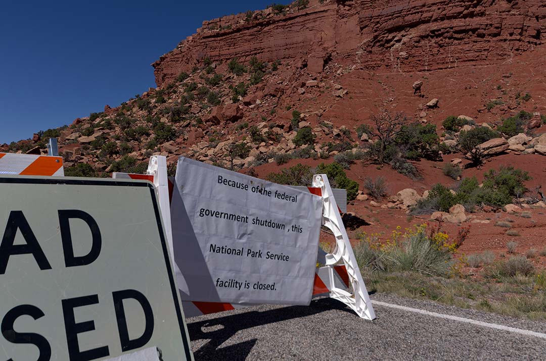
Closure sign at Natural Bridges National Monument
Well, the US government can’t get it’s act together, so all the National Parks and lands are shut down. After a bit of thought this morning, we decided to return home to Canada, since 90% of what we are doing here in the Southern US involves national parks and monuments. Without knowing when they may reopen, we just don’t have enough options to make it worth our while to stay here. So, tomorrow we will head back.
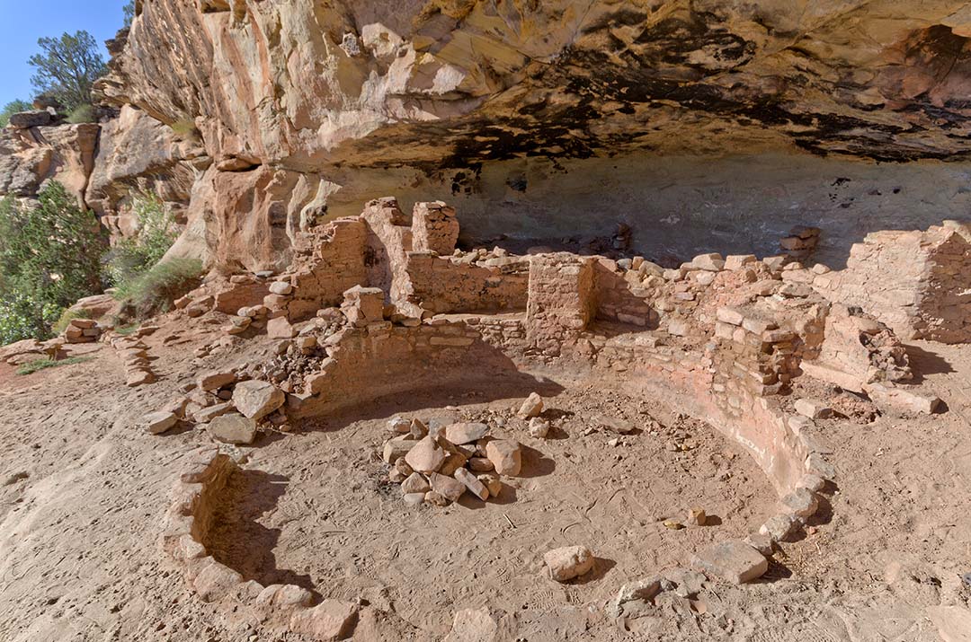
Five Kiva Pueblo
We did though really enjoy our last day of tourism. In the morning we drove to the Westwater Canyon, which is just outside of the town of Blanding, Utah. There we found the Five Kiva Pueblo at the end of Ruins Road. I scrambled down the canyon and up to the pueblo on the far side, but Enid did not. On the way back I found a better trail than the one I used to go in, so it was much easier to get back. However at one point I lost this trail too, and started climbing up some old footholds carved into the cliff. It was very hard to do while carrying a tripod, I was afraid I would fall, so I abandoned that route and managed to locate the trail once more. Then it was an easy hike.
A bit closer to town is a sign saying National Natural Arch, and a hiking symbol. We looked for a trail, and at first found nothing, then hit a well defined trail, but it only lasted for a short distance and disappeared. We walked through the open brush for a way, but decided it wasn’t worth while, so quit.
We then drove towards the Natural Bridges National Monument (which we assumed was closed, but we thought we would check if it was for sure). Along the way we stopped at the Mule Canyon Pueblo which is a restored site from one thousand years ago. When we did get to the park we found that it was closed. Four French people were there at the sign, not sure what was going on, and wondering what to do. They spoke very poor English, but better than our French, and I think they understood us as we explained to them that the government has shut down because of a funding controversy. We felt badly for them, as they have travelled here for about two weeks to see this beautiful part of Utah, and it is effectively closed. We marvelled at the stupidity of a government that cannot govern.
We drove to the Kane BLM Ranger station. It too was closed, but we ate our lunch on a picnic table there. Several other couples came by, one in particular from Tennessee, and we spoke to them. They suggested that we might want to go to Monument Valley, as it is Navajo run, so they thought it would be open. That became our plan.
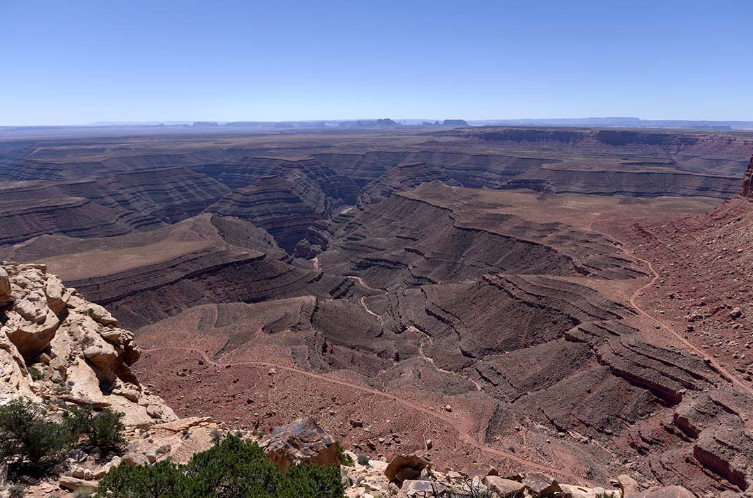
Mulie Point overlook over the San Juan River
However, when we got to the Moki Dugway, a very short steep section of gravel road that drops over 1100 feet in 3 miles from the top of Cedar Mesa to the valley floor, with very sharp switchbacks, we saw a sign that said “Muley Point”. We thought that this was the name of the viewpoint straight ahead of us which we walked out to, and took pictures at. A truck from Missouri had stopped there as well. But, as we were coming back to our vehicle, a small SUV came down the road and said it was well worth it to drive to Muley Point. We realized then that we were not where we thought, so took the dirt drive, about 3 or 4 miles, to the point, which had fantastic views out over the meanders of the San Juan river over a thousand feet below.
While there we spoke to the couple from Missouri again, and they recommended that we go to “The Valley of the Gods” instead of Monument Valley. They thought that the latter might be closed, as while it is run by the Navajo, it is a US National monument. So that is what we decided to do.
On the way down the Moki Dugway (actually a mining road from the 1950’s when Uranium was mined on top of the mesa), which is pretty narrow, just barely wide enough for two vehicles to meet, there is a viewpoint pullout near the top. We stopped here to take pictures, and a woman carrying an armful of necklaces came and talked to Enid. Enid looked at them, but didn’t offer to buy anything. As we were about to leave, I suggested to Enid that the price was really reasonable, and so she bought a turquoise pendant. The woman selling it told us that she was Dine, and so we told her that we also have Dene in Saskatchewan, and we had a short conversation about that.
At the bottom of the dugway there is an immediate left turn to the Valley of the Gods, but no sign coming down the hill. As we passed the sign on the other side of the road, we looked back, and realized that we’d missed the turn, so found a spot where the road was flat enough in the ditch that we could turn around. It looked like many others had used the same spot for the same reason.

Buttes in the Valley of the Gods
The recent heavy rains have caused all the washes to be quite rough. We were glad we were driving in a vehicle with high clearance and good suspension. We met a lot of smaller vehicles that I wouldn’t want to drive on this road. Perhaps they were rental cars, for as we learned in Hawaii, a rental car is better than a four wheel drive, for a rental car can go anywhere! We were glad that we made the drive, which took us a couple of hours (to go about 17 miles) as there are many large monoliths and buttes in the valley of spectacular red rock. So although nothing official was open, we very much enjoyed our day of driving through some spectacular Utah scenery.