El Malpais and El Morro, October 14

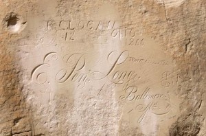
El Morro inscription

We didn’t have much information about El Malpais National Monument, but I wanted to go there as I had read that it had good hiking.  We drove the approximately 40 miles south of Grants, New Mexico passing a few signs that said “El Malpais” but not seeing any signs that indicated what there was to do there.  Finally we saw a sign that indicated there was an information center, so we stopped and got some advice.

The ranger suggested that we hike the El Calderon trail, so we drove back a couple of miles to where it started.  They have closed all the caves because of white-nose syndrome, except for the Junction Cave, so we walked through that.  It was a short lava tube of about 100 yards length, and quite rugged with old broken pieces of solidified lava that must have fallen from the roof.  From there we continued past Bat Cave, which you cannot enter anymore, but where you could certainly smell the bat guano.  About halfway around the hike is the El Calderon cinder cone, which is a crater about 50 m deep which last erupted perhaps 3000 years ago.  It is surrounded by walls of reddish cinders, which I climbed to the top for a good view out especially over the valley to the east.  While I was up on top, I spotted a man walking towards the crater with two dogs.  One of the dogs bared it’s teeth and snarled at Enid, before the owner called it off.

We arrived back at the car just before noon, so ate lunch as we drove on to El Morro National Monument.  We had no idea what was there, but the ranger at the El Malpais station had said it had rocks with petroglyphs, so we thought it might be worthwhile.  It turned out to be the third site we’ve visited unplanned (the other two being Hovenweep and Chaco National Monuments) which we’ve really enjoyed.  There are hundreds of names carved into the sandstone cliffs here, starting with petroglyphs of the Zuni people, then the Spaniards in the early 1600’s, through to the middle of the 1860’s when American settlers stopped here on their way west.  This was a stopping place for many people because there is a pool of water at the base of the cliffs, the only water for many miles of travel through the desert.

After looking at the carvings we continued on the trail to the top of the mesa.  It was a climb of about 200 feet and on top after following a trail which skirted the canyon below we came to a Zuni pueblo site, Atsinna, which has been partially stabilized.  The site was abandoned in the 1400’s.

It was fairly cold overnight, and there was frost on the windshield this morning; however, it warmed up through the day, and was a very nice temperature for hiking.

Posted in Going South, 2012 | Comments Off on El Malpais and El Morro, October 14

Bluewater Lake State Park, October 13

Bluewater Creek

As we drove through south of Farmington this morning we saw the results of the Navajo Dam irrigation project.  There were many green fields being irrigated, but the most interesting was a huge field of pumpkins.  There were dozens of semi-trailers lined up in the fields, thousands of orange pumpkins lying on the ground, and many tractors and workers out loading up the pumpkins.  Then not too much farther south the irrigation ends, and you drive for miles through dry sparsely populated desert.  There must be as many churches as there are people!

We got to this park early in the afternoon.  There is a lake here formed by a dam, but it is very low.  We went for a walk through the canyon below the dam.  There is a very tiny stream with almost no water which we crossed twice on rocks and logs.  On the way back we saw a very large hairy spider about two inches long.

It was very cold and windy tonight.  We are up high here and it is definitely fall.

Posted in Going South, 2012 | Comments Off on Bluewater Lake State Park, October 13

Simon Canyon, October 12

Simon Canyon Ruins

Not long after supper last night there was a very strong windstorm.  It was part of the thunderstorms that have been continuing today, but they are mostly wind and very little rain.  Last night’s storm whipped up a great deal of dust, and blew over our bikes which were standing behind the trailer.

Today we took it easy and read, played a game of scrabble, and then in the afternoon I went for a bit of a hike up to Simon Canyon.  Enid walked around the campsite a bit.

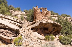
At Simon Canyon there is a small rock pueblo structure on top of a large rock.  However this is a very recent site compared to those we have been seeing, and is of Navajo origin.  It is believed to have been constructed in the 1770’s, and looks very much like a fortress position from it’s difficult-to-access site on a high bolder.

The sign at the ruins reads: “The Simon Canyon site is the most northwestern of the structures attributed to the Gobernador phase of Navajo history (1700 – 1775).  The site consists of a single room on a large bolder.  The room is rather well preserved with the greater part of the roof intact.  Of all the remaining structures of this period in Navajo history, it appears to have been the most vulnerable to Ute raiding which has frequently been named as one of the causes for the Navajo abandonment of the area.  There are no other sites in this vicinity which have been attributed to the Navajo.   The site position north of the San Juan River separates it from the major contemporary Navajo populations in Gobernado and Largo canyons.  Simon Canyon Ruin was nominated to the National Register of Historic Places in 1975.  The site was stabilized by the BLM stabilization team in 1975.”

Posted in Going South, 2012 | Comments Off on Simon Canyon, October 12

Chaco Culture, October 11

Pueblo del Arroyo

Since we were not able to reserve the site we were at for more than two nights, but we want to stay here another two days, we decided to move to the site right next to us, which is not reservable.  The first thing we did this morning was to move our camping chairs over, and then parked the Tahoe in the new site while we ate breakfast.  After we’d made our lunch for the day we moved the trailer and set it up again.  It’s the shortest distance we’ve ever moved.

After that we drove to Aztec to view the Aztec Ruins National Monument.  It has nothing to do with the Aztecs, though early settlers here thought it did, so the town and ruins are misnamed, but is another of the many archaeological sites in this area of the ancestral puebloans.  We caught up to a tour guide just shortly after we arrived.  There were only two others in the tour, and the guide was very good, so we got a good lesson on the culture of these people.

While eating lunch we decided on a whim to drive the approximately 70 miles to the Chaco Culture National Historical Park.  About twenty kilometres of the road is terribly rough washboard.  It reminded us of some of the “corrugated” dirt roads we were on in Australia.  However our Tahoe has much better suspension than our Australian motorhome did, so the ride was much, much better.

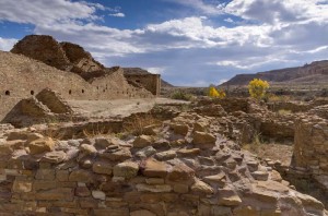
We were astonished at the size and number of the ruins at this park.  They are by far the best that we have seen while travelling through this area.  There were a lot of very skilled stone masons here in the late 1200’s.  Together with the dry climate, their skill has meant that many of the buildings with their two or three story high stone walls are still standing.  The weather is changing, and so it made for beautiful pictures with storm clouds moving in against the deep blue southwestern sky and highlighting the ruins.

Posted in Going South, 2012 | Comments Off on Chaco Culture, October 11

Exploring Navajo Lake State Park, October 10, 2012

Marina on Navajo Lake

We spent a quiet day today.  In the morning we drove to the other side of the San Juan River, and to the large earth dam that forms Navajo Lake.  The dam is about 400 feet high.  It has a huge spillway, but that was totally dry, and the upstream side was a long way above the water since the lake is very low.

We stopped at the park station, where the sign said closed, but the door was open, so we walked in and talked to the park ranger.  He gave us a map of the park, and told us about some of the other parks in New Mexico.  He also told us the best places to hike, and about some petroglyphs.

We drove to the area of the cliffs where he said the petroglyphs were, and explored up and down along the high rock walls.  There were a few areas with petroglyphs, though almost all had names scratched into the rocks as well.  We weren’t sure if the petroglyphs were old, or just recent creations.  Two large horse carvings, one of an entire horse, and another of just a head looked suspiciously modern to me.

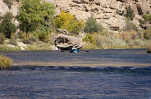
After lunch, which we ate by the river, we watched fishermen in boats floating down the river and through the tiny rapids that are here.  I fell asleep in the warm sun at the edge of the river with my head on Enid’s lap. 

When we got back the camp host was delivering wood to our neighbor.  I asked her if I could buy wood, but she said they don’t sell it in this park, and she had just picked up the wood in other campsites and was giving it to our neighboring camper.  She suggested just going out on the BLM land near here and collecting wood, and so that is what I did.  With that we had a nice fire and wiener roast for supper tonight.  It was in general a pretty relaxing day.

Posted in Going South, 2012 | Comments Off on Exploring Navajo Lake State Park, October 10, 2012

Navajo Lake State Park, October 9

Fishermen in the San Juan river

We bought groceries in Durango this morning before heading south approximately 100 km to Navajo Lake State Park, where we have a campsite reserved.  Just before the campground the road becomes a gravel road, then changes back to pavement as it enters the state park.  I guess that is because the access road is a county road, but the roads in the park are maintained by the state.

After we’d set up our trailer we biked a few km further down the road to the trail head for the Simon Canyon trail.  We started cycling up this old road as well, but it soon got too steep, and we weren’t in the need of great exercise, so we turned around.

There were quite a number of people fishing in the river.  There is supposed to be good trout fishing in the waters of the San Juan River here below the dam.  There definitely is a lot of natural gas production here, as we passed many well heads, and signs about pipelines along the road.

Posted in Going South, 2012 | Comments Off on Navajo Lake State Park, October 9

The Million Dollar Highway, October 8

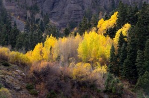
Red Mountain pass fall colors

We drove north on the “Million Dollar Highway”, so named because it supposedly cost one million dollars per mile to build in the 1920’s.  We hoped to see some of the fall colors on the mountains, and we did at lower elevations.  However, by the time we reached Silverton at 9300 feet, all the leaves have fallen.

We did enjoy the morning in Silverton, stopping at their historical museum.  For a small town they have done a very credible job of covering the mining history of the area.  Since today is Canadian Thanksgiving, we celebrated by eating lunch at “Thee Pitt’s Again”, which Enid had seen on the Food Network’s show “Diners, Drive-Ins and Dives”.  We were the only customers in the restaurant, just before noon, and had a pulled pork sandwich.  There weren’t very many people in town, though when the tourist train from Durango arrived a few minutes after twelve, the population of the town probably doubled for the train’s two hour stop.  The waitress in the restaurant told us that they would be shutting down for the season next Sunday.

After lunch we continued on to Ouray.  This is the really spectacular part of the drive, or should I say, the really scary part of the drive.  The road is narrow (in a couple of spots it actually has no shoulder at all as the right hand side of the road out over the canyon is falling away) and filled with hairpin turns of ten or fifteen mile per hour speed curves as the road crosses Red Mountain pass at 11,018 feet and then drops down to the tiny town of Ouray at 7792 feet in just a few miles.  Most of the curves have no guard rails, and I think Enid did much of the trip with her eyes closed.

Ouray is a bit bigger than Silverton, but it too seems to be a town built on tourism.  We had planned to swim in their hot springs, but it was a rather cool day without much sun, so we decided instead to just head back to Durango.

Posted in Going South, 2012 | Comments Off on The Million Dollar Highway, October 8

Durango, Colorado, October 7

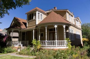
Historic house in Durango

It was a short drive across to Durango this morning, so we arrived at our RV park site early.  The site we were supposed to be in was not yet empty, so they gave us a different one.  We set up the trailer, found that the water hose was dripping and then ate lunch.

After lunch we drove back to Durango (we are about 5 km north of the town) and first stopped at a flea market, where we bought four books for one dollar.  Then we drove to Old Town Durango, the center of the historic district, which has been generally very nicely refurbished.  It reminded me of Banff with all it’s tourist shops, though quite a bit bigger.  We walked around looking at some of the older buildings (though none are really old, the town having been founded in the early 1880’s), and did some shopping.  I looked for hiking boots, but didn’t find any I really liked.  I did buy a new pair of running shoes which were on sale.  The highlight purchase though was some chocolate almond bark and macadamia nut clusters in dark chocolate.  After looking at the shopping section we walked through the area with the oldest houses.

Following that we drove to Walmart where I bought a new hose coupling.  That did stop the leaking water hose.  Perhaps though I should have left it leaking, as it is supposed to get quite cold tonight, and I don’t want our water pipes to freeze.

Posted in Going South, 2012 | Comments Off on Durango, Colorado, October 7

Hovenweep National Monument, October 6

Painted Hand Pueblo

Sometimes just doing what happens is a good thing, and that’s how it turned out today.  We first drove to Four Corners, which is an interesting enough location, particularly when you realize how the surveying of the original boundaries of Utah, Colorado, New Mexico and Arizona were originally carried out more than one hundred years ago.  The inaccuracies in the survey were really quite slight, given the technology in use to make the measurements.  Today using a GPS you can see how the actual spot is not where it was intended to be, but has nevertheless been adopted as the legal location based on the original survey.  So on an accurate map, there is a slight bend in the boundary of Utah and Colorado to make it meet at the Four Corners.

It is an interesting spot, but not one where you’d likely return to (though for Enid, this the second time, though separated by almost fifty years).  After we left there we weren’t sure where we would go next.  Marked on the map just outside Cortez is Yucca House National Monument, but we had seen no highway signs on our way to Four Corners this morning.  We tried to find information about it in our tour guides we’ve picked up along the way, but found nothing.  However, we did see that there was information about Hovenweep National Monument, so we decided to go there.

That was our good fortune.  It is a very interesting spot with a large collection of ancestral puebloan houses on the mesa beside a small canyon.  The buildings are in very good condition, considering they are about 800 years old.  There are many towers here, both square and round.  The stone work is well done, and though it has survived well partially because of the extremely dry desert climate, it is also indicative of the quality of construction done by these ancient people.

We had two options when we left the visitor center to return to our campsite in Mesa Verde, as we could have either turned right or left, both indicated as 42 miles to Cortez on the road sign.  The GPS route said go right, so we did, although on the map it looked liked the poorest road.  While it wasn’t a great road, it was paved all the way.  A few miles down the road we saw a sign pointing down a dirt trail to “Painted Hand Pueblo”, so we decided to see what was there. 

That was our second lucky decision of the day.  There we found another very interesting tower pueblo and this one had very faint hand print pictographs in a rock alcove with some remaining walls, that once would have been a room below the tower.  The trail down to the tower was fairly rough and undeveloped, but Enid says if there are pictographs and ruins to see, she doesn’t mind a bit of rock climbing and scrambling!

We also discovered that there is a lot of irrigation and farming as we drove back to Cortez.  We passed may fields of alfalfa that were being cut and baled in huge square bales.  There is an enormous contrast between the dry red desert soil and the verdant green of the alfalfa where it has been irrigated.  It does show that the soil could produce for the ancestral puebloans when they had water, but that drought was probably the enemy that drove them from this area.

Posted in Going South, 2012 | Comments Off on Hovenweep National Monument, October 6

Mesa Verde National Park, October 5

Balcony House and tourists on exit route

Enid had visited here when she was young, and often spoke of the cliff dwellings.  They must have impressed her then, as she has always had a strong interest in culture and anthropology.  I know that she certainly enjoyed seeing the dwellings over the past two days.

We drove and walked to many viewpoints today.  We saw the history of the area displayed in archaeological sites that began in about AD 600, until the area was abandoned in the late 1200’s.  We also spent quite a bit of time in the museum, which is an older museum, but has some good artifacts from this area, from archaic times to the ancestral puebloans.

Deer in campground

It is definitely fall here.  The leaves on the sides of the mountains have almost all turned color, so it was a very pretty drive up to the top of the mesa today.  The campsite is very nearly empty, and the mule deer feel free to roam throughout the sites.

Posted in Going South, 2012 | Comments Off on Mesa Verde National Park, October 5