Bar U Ranch, July 11

Bar U Ranch

We stopped at Pincher Creek to get gas, groceries, and some screws and washers to fix another of the broken braces on the trailer skirting.  I also bought a small fan for use in the trailer, as we won’t have electricity for the next five days, and so will have to run it from the inverter.  We really appreciated having a fan like that in Australia, and since it is so warm out right now we think it will be good here as well.

We saw a doe and fawn by the side of the road just before we got to Pincher Creek.  The doe was on one side of the road, the fawn the other, but the doe walked back across the highway.  We were nearly stopped and so could see the two of them out the Tahoe window.

We then drove north on highway 22 towards Longview.  I’d noticed a sign about the Bar U Ranch National Historic Site quite a bit earlier, and so when I saw another sign indicating it was a kilometre ahead, decided to stop, especially as it was time for lunch anyway.  We went into the small museum, which you can tour for free, and decided to eat before we paid for entrance to the grounds.

It was a really nice way to spend a few hours, touring the old ranch site.  Many of the buildings have been restored with displays of ranch life.  At the cookhouse, one of the on-site interpreters was baking rhubarb crisp in the wood oven.  It was pretty hot in the kitchen, given that it was nearly 30 degrees C outside, and she had a good hot fire going.  We also saw the display of the round-up camp, where they have a chuckwagon and some wall tents set up.  The interpreter here had a fire going with kettles of boiling water and coffee hanging from hooks supported by branding irons.  We had a cup of tea, and she explained how the round-ups worked, with cowboys from several ranches working together to identify and brand cattle in the spring, and send them to market in the fall.  Later we came back and had some freshly baked bannock.

We got a short ride on a wagon drawn by two Percheron horses, and then got off to watch a ferrier as she shoed one of the massive feet on another of the Percherons.  The driver unhitched the horses from the wagon while we were watching, and led them to the river for a drink.  Some young children had been watching in awe as the horse shoe was nailed on, and then followed down to watch the horses get a drink.

We walked back and visited some of the other display buildings, then got back on the wagon.  We got a nice long ride as the driver took us through a field and a very lovely view out over the ranch site, rather than the short direct route back to the information centre.

It is unfortunate that the Canadian government has cut funding for Parks Canada, which includes these important heritage sites like the Bar U Ranch.  They are such an important part of maintaining our culture and history.  The cost of running them is small compared to the wealth of benefit to Canada in helping to understand our heritage as a nation, and why we are the people and country that we are today.

After a very nice afternoon at the ranch, where the weather was spectacular, we headed to Peter Lougheed Park to camp.  The drive across on highways 540 and 40 is beautiful.  It passes over the Highwood Pass, which at 2280 m is the highest highway point in Canada.  We are in the Boulton Creek campground.  Our site is very long and narrow, so it was a careful backing in with the trailer.  There is just room to get around the sides of the trailer before the gravel pad drops off about three feet sharply on each side.  After supper tonight I fixed a leak in my bike tire, and then we went for a ride around the campgrounds.

Posted in Summer, 2012 | Comments Off on Bar U Ranch, July 11

Summit Lake, July 10

Summit Lake

Yesterday we met a woman on the trail who suggested we go to Summit Lake.  She said there were many glacier lilies there.  Today we took her advice, and hiked up to the lake.  It was very beautiful.

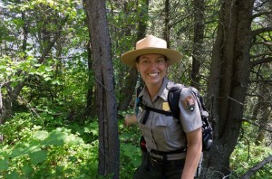
It was slightly cloudy this morning when we started, but the clouds soon blew away, and by mid-morning it was bright and sunny.  As we neared the top of the switchbacks on the trail up from Cameron Lake, we were caught up to by two female park employees.  We talked to them a bit about the flowers we were seeing, and discussed our plans and theirs for the day.  They were going over the Carthew Pass, and one of them was also setting up a geo-cache site at Summit Lake.

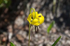
Glacier Lily

The last part of the trail was wet, as there is still the last remnant of snow in the trees.  We saw many yellow glacier lilies, as well as a lot of white spring beauty flowers, and both Enid and I took many pictures.  The lake was not much farther down the trail from the best flowers, and very pretty.  The far south shore in the shade was still snow-covered, and there are high mountains in the background in Glacier National Park.  Since it was still quite early, we continued on climbing about half way to Carthew Pass, where we stopped at a spot where we could look out over the boundary valley to the south towards the United States.

As we left the Cameron Lake parking lot we came upon some parked cars and motorcycles just a short way down the road.  There was a female brown colored bear and her black cub.  She was walking slowly across the road, and at first the cub was hiding in the grass, but shortly hustled across the road and disappeared into the trees.

The park interpreters we met this morning had suggested we drive the road to Red Rock Canyon to see the flowers there, so we did. The north edge of the park is where you can clearly see the sharp transition from prairie to mountain, and there are very pretty scenes where the prairie flowers and grass are backdropped by the red-stoned mountains.  However we did not stay long, as a large cloud was rising over the mountains to the west.  As we reached the end of the road, it started to rain, and then hailed.  I was worried that it would break the windshield, but we soon drove out of the storm.   Then just as we got back to town it opened up and poured rain and hailed again.  We sat in the vehicle at the campsite while we were pelted by marble sized hail.  Many of the campers here were out struggling to take down their awnings.  After the storm we saw a number of them on the roof of one of the trailers, working on the awning.

After supper Enid sat on the shaded side of the trailer to read and discovered that we had another flat tire, on a different tire this time.  It wasn’t as low as the previous one, but was obviously leaking, so I took it off, went to the tire repair shop again, and he was able to fix it.  One nice thing about a small town is that you can get repairs at all hours!

Posted in Summer, 2012 | Comments Off on Summit Lake, July 10

Wall Lake Hike, July 9


Wall Lake

Today we hiked from Alberta to British Columbia!  Well, that distance wasn’t too far, just about two kilometres.  Our destination was Wall Lake which is a quite nice walk into the Akamina-Kishnena provincial park.  The trail climbs until you reach the Alberta-British Columbia border, then it is quite level from there approximately another four kilometres to Wall Lake.

We started our day with a drive to Cameron Lake, which is not far beyond the Akamina Pass trailhead.  This lake has boat rentals, but early in the morning it wasn’t very busy, and is a very pretty lake nestled below towering mountains.  We met the German couple there who had been on the International Peace Hike with us two days ago.  They were going on a guided hike up to Summit Lake.  We however returned to the trailhead. 

There were two men and a woman getting ready to go hiking (at least we thought all three were going, but only the two men actually were on the trail).  As I’d neglected to bring the park map, we weren’t sure if this was the right trailhead to Wall Lake – in fact I couldn’t even remember the name of the lake – but these people had a rough map, so I could see that this was where we wanted to start.

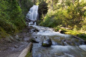
Forum Falls

There were very few wildflowers along this trail.  However, there is a very nice waterfall, Forum Falls, which is just a little over 200 m off the main Akamina trail.  It was very cool by the falls, a relief as it was another very warm day.  There is a campground just a short distance past the falls junction on the main Akamina Pass trail, followed almost immediately by the junction to Wall Lake.  You cross the creek, and then it is a fairly level walk into the lake.  The lake is not large, maybe a kilometre across, and completely surrounded by high rock cliffs  rising sheer a thousand metres above the lake.  There was a slight current in the lake, which we could tell from the moving pollen covering the water, as well as some logs and ice floes that were drifting towards the exit stream.

There were a great number of downed trees along the lake shore.  Many of them were very large trees, half a metre in diameter, and they were all snapped off several feet above the ground, or else directly uprooted.  They had very recently been cut through to reopen the trail.  We followed the trail towards the end of the lake (and the toilet) but that was as far as we could go.  Beyond this they had not cut the trail, and it was a tangled mess of downed trees, and old snow banks, so it looked very much like an avalanche.

We ate lunch back about halfway from this point and then headed back.  Just as we rounded the first bend after leaving the lake, we came across a young park ranger.  He had a can of gas that he was loading into a backpack, and a mountain bike.  We talked to him and found that they had just cut out the trail on Friday, and the gas had been stashed in the bush.  He said they were not sure what had taken down the trees, but though it was a class 3 or 3 ½ avalanche.  They thought that perhaps an entire cliff of snow had broken free right to ground in the late spring.  The power of the avalanche must have been tremendous, as it is almost a kilometre across the lake from the base of the cliffs where the avalanche would have landed.

It was very hot in the afternoon.  We refilled Enid’s water bottle at the creek before leaving the lake, and the water was lovely and cold.  Then we filled it again when we got to the Akamina campsite.  The water was excellent and what was left made much nicer tea for supper than the heavily chlorinated water here in the trailer camp.

Posted in Summer, 2012 | Comments Off on Wall Lake Hike, July 9

Biking Around Waterton, July 8

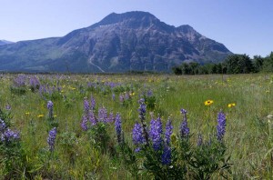
Flowers and mountains in prairie fields at Waterton

It is another beautiful, sunny and calm day.  We decided to try biking this morning, so I cleaned up the chains on our bikes, which were pretty dusty from the trip here.  I discovered that my front tire was flat, so pumped it up.  It seemed to be holding air, and the valve doesn’t seem to be leaking; however, to be safe we stopped at the bicycle shop here and bought a new tube.

We stopped at the outdoor store and got some Freesole to fix Enid’s shoe as well as her bike helmet (a pad has come unglued).  After that we peddled north up the hill to the Prince of Wales Hotel and took a look around the impressive lobby.  From there we continued up the highway until the bike path starts at Linnet Lake.  We stopped along the bike path several times to take pictures until we came to the road that branches off to the stable and a picnic site.

Not far down this road was a barricade.  We kept on going down the gravel road until we came to a major washout where the culvert was half uncovered.  After walking our bikes across this we continued on down the road to where it meets the Waterton River.  It appears that at times they ford the river here, but the river is very high right now so that would be impossible.

Along the way there and back we stopped several times to take pictures of the spectacular scenery.  There are large prairie fields filled with grasses and wild flowers with a backdrop of mountains towering over them in the background.  It was a pleasant way to spend a warm sunny morning.

Posted in Summer, 2012 | Comments Off on Biking Around Waterton, July 8

International Peace Park Hike, July 7

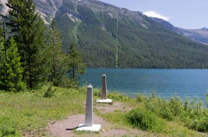
Canada-US border

We left with an international group of about 20 others this morning on a guided walk across the Canada-US border.  There were a few Canadians, a couple from Germany, a mother with her young daughter from Australia though now living in Kabul, Afghanistan, and a larger number of Americans.  We were led by a US park ranger, and a Canadian park interpreter, and walked along the lake to the south end of Waterton Lake.  Although the hike information said 13 km, it registered as closer to 16 on my GPS.  Though the hike climbed up and down a bit, it never rose too steeply, which was a good thing today, as it was very hot.

Bear scratch tree and US Ranger

We stopped about every half hour to get the group recombined, and listen to information about the park from the guides.  Yesterday we had seen a number of trees wrapped with barbed wire.  It didn’t seem to make much sense as to why someone would do that, but today the ranger explained it to us.  The bears rub and scratch themselves on trees, and when they do so they rub off some of their hair.  The park naturalists have identified the trees used by the bears for this purpose, and when the bears scratch, they leave behind some hair stuck in the wire.  By studying the hair they’ve been able to establish that there are about 700 different bears in the park.

We ate lunch at the boundary.  Shortly before that I got to play the role of one of the US park founders, and had a script to read about the international boundary and formation of the peace park.  Once we’d crossed the border the trail became quite a bit flatter, but the vegetation was much more dense.  There were many place where the cow parsnip and other plants and grasses were so tall (more than waist high) and thick that you could barely see the trail.

Near the end of the trail you cross the Waterton River on a suspension bridge.  Though the bridge is about a metre across, it isn’t very heavily constructed so had a weight limit of one hiker at a time.  Shortly beyond that we reached the Goat Haunt customs station where we had to clear US Customs, and got our passports stamped.   Really, that is a tourist exercise, since the customs officials ride in and out each day from Canada on the ferry, and I visited with one of them on the boat ride back down Waterton Lake.

Posted in Going South, 2011 | Comments Off on International Peace Park Hike, July 7

Hiking to Lower Rowe Lake, July 6

Three-spot Mariposa Lily (Calochortus apiculatus)

The trailer tire was completely flat this morning, so I removed it after breakfast, and left it at the tiny service station here in Waterton.  The man who repairs tires was not there at the time, so I left a note with instructions hoping that it could get fixed, while we were out hiking.

We drove to the information centre to check on hiking trails, and got some advice that helped us decide to go to Lower Rowe Lake.  It was a beautiful hike, not too steep, with a large number of flowers along the way.  Many of the spring flowers were new ones for us.

Bighorn sheep

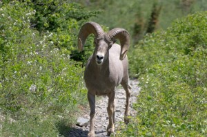
We ate lunch at the lake, and walked a bit farther to get a view of the waterfall that drops a couple of hundred feet from Upper Rowe Lake down to this one, before returning.  At about one third of the way back down the trail we spotted some bighorn sheep off to the side.  We walked as quietly as we could, hoping to get a better view.  We need not have been quiet!  The sheep came right down the path we were walking on, and the largest ram walked almost up to us, eyeing us, then finally stepped of the trail.  The three rams nonchalantly grazed in the brush just above us as we continued on down the path.

After our hike was completed we drove back to the information centre, and got more details about our hike for tomorrow, which is across the international border.  It’s a good thing we did, as we learned that we had to get our boat tickets for the return trip today, so we did that on the way back to the trailer.  We also picked up the tire which was repaired.  Then we went to the grocery store and bought a litre of ice cream.  That tasted good, as it has been a very warm day.

Posted in Summer, 2012 | Comments Off on Hiking to Lower Rowe Lake, July 6

Travelling to Waterton, July 5

We left Prince Albert early Wednesday morning, and travelled to Bickleigh.  It was incredibly windy, from the southwest, which of course was the direction we were heading, so our gas mileage was very poor.  The wind was so strong that it broke one of the clamps holding the skirting on the side of the trailer.  We stopped just outside of Harris and tied the broken clamp to the frame of the trailer with a piece of rope.  We stopped in Rosetown to see if we could find some flat aluminum to use to fix it, but found nothing, so decided we might as well go to the farm to see Duane, as we were sure he’d have what we needed.

Duane manufactured two nice heavy clamps, one for each side of the trailer, so we have that fixed.  Enid drove in to Eston and picked up her mother and brought her to the farm overnight.  We left the farm on Thursday morning, a lovely day with almost no wind.  After leaving Florence at the lodge in Eston, we continued on west, and reached Waterton National Park in mid-afternoon.

Enid thought one of the tires on the trailer looked low.  By the time we had finished supper it was obvious that the tire was losing air, so we plan to see if we can get it fixed tomorrow.

Posted in Summer, 2012 | Comments Off on Travelling to Waterton, July 5

The West Side of Death Valley, December 10

Aguereberry Point, Death Valley National Park

This is our last day in the park as tomorrow morning we start on the long trip home for Christmas.  We travelled to the west side today.

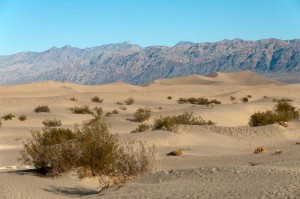
Our first stops of the morning were to photograph the Devil’s Cornfield and the Mesquite Dunes.  The cornfield is a lot of approximately 1 meter tall plants, widely spaced, that do look a bit like corn plants at a distance.  Mostly though it is just a lot of sand.  We walked just a short distance into the dunes, but saw some interesting tracks.  A park ranger was there preparing for a walk and talk, and she had cards with her showing the footprints.  One of the more interesting tracks is left by a large stink beetle.

We then drove up the Emigrant Canyon road, all the way to the charcoal kilns.  The last few kilometers of this road is rough gravel.  We’d expected to see a few small mounds of dirt used to make charcoal.  We were very surprised to find a large number of tall stone “beehive” shaped kilns, at least 25 feet high and 30 feet in diameter.  They were used in the late 1870’s to make charcoal for a smelter about 60 kilometers to the west of here.  Each kiln had a door at ground level, and numerous vents around the lower perimeter.  Then there was a door about two thirds of the way up, and a number of vents in the top that seemed to be plugged with jagged stones.

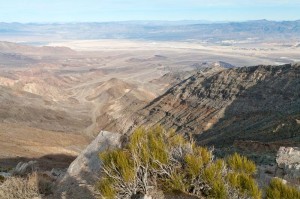
From here we drove to Aguereberry point, a high rocky viewpoint with a spectacular view out over Death Valley from a height of almost 2000 metres.  The road was a narrow twisting gravel road, barely big enough for one vehicle.  If you met another vehicle at many of the turns, one of you would have to back up and find a place to let the other vehicle by.  Fortunately we met no one either going up or down.  The last 400 metres are a very steep and narrow trail, not much wider than a footpath, with shear drops off the side.  I felt a bit intimidated driving on the road.

Finally we stopped at an old abandoned gold mine ruins, and the ruins of an old house, and that concluded our travels around the park.  We filled up with gas here tonight so we are ready to leave first thing in the morning.  At five dollars per gallon (almost two dollars per gallon more than we’ve been paying) it cost us $100 to drive around for the last three days, but the views have been well worth it.

Posted in Going South, 2011 | Comments Off on The West Side of Death Valley, December 10

Scotty’s Castle, December 9

Scotty's Castle, Death Valley National Park

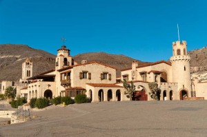
This morning we drove about 100 km north of our campsite here in Furnace Creek to Scotty’s Castle.  This is a large personal retreat complex built by wealthy financiers Albert and Bessie Johnson of Chicago, together with their “partner in crime” Walter “Scotty” Scott, between about 1922 and 1931.  Scotty was really a con man, telling everyone that the he was building a castle over his gold mine.  However, there never was a mine and the castle wasn’t his either.

For the first hour of the tour we were guided by a young lady in 1939 period costume, who took us throughout the upper portion of the castle.  We saw several of the rooms outfitted with the Johnson’s original furniture.  The furniture was beautiful, but hard to see as it was kept very dark in the house.  However it shows up well in the pictures we took.  There was an incredible amount of ceramic tile throughout the house.  Much of the tile was custom designed for them as it had their logo on a lot of the tiles.  The dishes were similarly marked with their initials.  There was a great deal of silverware and other fancy furnishings throughout the house.

The house and building complex must have cost a very large amount of money, for it incorporated all the latest technology of the day, such as solar heated water, refrigerator, and their own hydro-electrical generating plant based on a Pelton water wheel.  In the second part of the tour we got to see under the castle, and got a good view of how the technology was incorporated into a tunnel system connecting the buildings.  In 1931 construction was abandoned, we suspect because the Johnson’s had lost a great deal of money in the depression; however the circulated story is that they were in a conflict with the federal government over their land boundary.  Supposedly they had built the house on land that was mis-surveyed, and their true parcel was over two kilometers away.  This land claim was not settled until 1937, and construction that had stopped was never restarted.

Because the construction was abandoned, one of the most obvious uncompleted features is a huge swimming pool.  It would have had two pools – one a shallower swimming pool at least 20 metres long, and another deep diving tank, about the same length and at least three or four metres deep.  The walls of the pool are in place, but the floor was never poured.  On the basement tour we saw stacks of tiles that were to have been used for the walls of the pool, but never installed.

Mesquite Sand Dunes, Death Valley National Park

After this morning at the castle showing how these wealthy people interacted with their environment in the 1920’s, we got back to our visit to the natural environment of Death Valley.  We drove to Ubahebe crater, which is a steam and magma explosion crater, believed to be only about 2000 years old.  Then we drove in to the end of Titus Canyon.  It looks like it would be an interesting drive as the narrow one-way single lane gravel road winds around for thirty kilometers through the rocks of the canyon.  We walked up the road, but only for about 500 metres.  Finally we finished the day with a short interpretive hike at Salt Creek.  It is the most water we have seen in Death Valley, a small stream about a meter wide and maybe 10 cm deep – and very salty judging from the salt crystals in the mud of the stream.  The stream flows out into the salt flats north of Furnace Creek, to the area where they mined borax in the late 1890’s.

Posted in Going South, 2011 | Comments Off on Scotty’s Castle, December 9

Death Valley, December 8

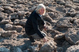
Enid at salt deposits, Devil's Golf Course, Death Valley Nationa

Death Valley is stunningly beautiful.  Strangely it is a land shaped by water, yet water hardly exists within it.  The valley floor is mostly the remains of old and dessicated lakes, while the surrounding rugged mountains are sculpted into crags and eroded valleys by occasional but rare floods of water.  Over thousands of years they have left their marks.   With almost no intervening water erosion, the scars left by water in the past stand out everywhere.

There are almost no plants, except for the occasional salt tolerant bush like Desert Holly.  The ground looks like the aftermath of some gigantic fire, yet there is almost nothing here that would burn.

This morning we were amongst the first, if not the first visitors to the historical ruins of the Harmony Borax Works.  Here there is a short interpretive trail around the old 20 mule team carts, the boilers and troughs where the borax was crudely refined, and remnants of old buildings.  We drove out on the Mustard Canyon road, aptly named for the yellow coloured dirt that makes up the walls.

We drove south towards Badwater, stopping along the way at the Devil’s Golf Course.  Here at the northern end of Badwater Lake are very rough and rugged salt deposits.  It looked like dirty river ice that has just broken up and piled along the shores.  We kept repeating that it looked like it should be cold and slippery, but it wasn’t of course.  It was very hard and jagged and tough to walk over.

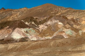
Artist pallette, Death Valley National Park

At Badwater there is a very small amount of open water with salt crystals floating in it.  The small pond of water reflected the high rock walls of the mountains on the east side.  Almost a hundred meters over head is a sign that reads “Sea Level”.  This is the lowest place in North America.  We walked out for at least a kilometer onto the salt pan.  So many people have walked on the salt that the crystalline structure is flattened out, until you get a  long way out onto the dry lakebed where you can see the ridges the salt crystals have formed.  Once again we commented that it looked like dirty ice, and we expected it to be slippery.  It wasn’t.

We ate lunch, then hiked in about 2 kilometers to the Natural Bridge.  Next we drove the Artist’s Drive road,  a one way paved road for several miles that rises up to beautifully colored rocks – chocolate browns, reds, greens and yellows.  One point called the Artist’s Pallette is particularly spectacular with bright colors.

By now we had walked quite a bit, mostly just short walks of a kilometer or so, but enough that we were both tired.  However we decided to go on one more hike into Golden Canyon.  It was about 4 kilometers return, and rose almost one hundred meters, but it seemed like an easy walk.  It was worthwhile, as the rock walls of the canyon were carved into many stunning shapes, and golden colored in the late afternoon sunlight.  The grade was not too steep, in fact, it used to be a paved road, but it washed out in a flash flood in 1976.  Remnants of the pavement existed in a few spots.  It reinforced how much of a role water has played in shaping this arid desert.

Posted in Going South, 2011 | Comments Off on Death Valley, December 8